Written by Mark Clark, Associate Professor, Wetland Ecology with UF/IFAS Soil and Water Sciences Dept.
Tropical Storm Elsa passed 35 miles west of Cedar Key on July 7 with a peak wind gust of 49.6 kn. A maximum storm surge of 2.56’ ft occurred at almost the peak tide just after noon EST. Water levels reached 4.44 ft above MSL or a little over 3 ft above the mean high-water line.
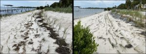
Three living shorelines have now been constructed around Daughtry Bayou in Cedar Key. “Joe Rains Beach LS” was constructed in early 2017. Vegetation along that shoreline is dense and well established with extensive root structure. Two newer shorelines, “G Street LS” constructed in summer 2020 had additional wave protection added in late spring 2021 and “Airport Road LS” constructed in late fall 2020.
Despite having planted over 10,000 plants in the upper and lower saltmarsh zones, vegetation on G Street and Airport Road had only one growing season to become established. In addition, G Street and Airport Road locations are relatively exposed shorelines and had multiple lesser storm impacts over the past year from outer bands of Hurricane Sally, Tropical Storm Eta, and multiple winter cold fronts that create considerable wave energy out of the southwest, which these shorelines are most vulnerable to.
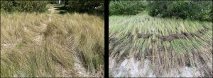
At Joe Rains Beach LS, where vegetation is well established, soils showed little or no evidence of erosion and vegetation was only temporarily laid down, but rarely uprooted. The low marsh at G Street LS and Airport Road LS were also minimally affected due to wave protection at lower water from Reef Prisms and Reef Balls. In contrast, the high marsh and adjacent dune at Airport Road LS had some significant erosion resulting in 3-5 horizontal feet of sand being lost along with Sea Oats, Seaside Goldenrod and Bitter Panicum. Additional erosion in the high marsh of both sites resulted in Saltmeadow Cordgrass being partially uprooted or lost.
Despite some loss of vegetation and sand along the G Street and Airport Road Living Shorelines, rooted vegetation is beginning to recover, and additional plantings are planned to fill in the area where the dune eroded. Most importantly, the “toe” of the concrete apron adjacent to the roads was still well protected and is the underlying goal of these living shorelines to protect coastal infrastructure. In addition, although some vegetation and sand were lost, habitat for fiddler crabs, horseshoe crab nesting, birds, fish and many other species continues, which is the added benefit of a living shoreline, to provide infrastructure protection while promoting and enhancing ecosystem services.
 0
0
