Change is the only inevitability.
We see it echoed in the metamorphosis of insects, the too-quick growth of our children, the gray in our hair. From one moment to the next, the cells that comprise our bodies are shifting, changing, dying, regenerating. The planet too changes, in cyclical patterns or abruptly, suddenly, and occasionally catastrophically. Often this change is too subtle for us to notice or moves at the pace of stones and therefore escapes us. In our efforts to grasp the changing world, we create maps, models, lists and diagrams.
What is a Hardiness Map?
As a tool for understanding, our maps and lists can give us a path forward, a set of parameters for how we interact with the natural world and landscapes that we inhabit. The USDA Hardiness Zones map is one such tool. A standard by which gardeners, landscapers, foresters, and urban planners can make decisions about the plant species best suited to a geographic region.
Plants evolved in specific ecosystems, with a range of climatic adaptations. Some plants can withstand the bitter cold of an arctic winter, others can withstand frequent root inundation due to heavy rainfall, still others can avoid desiccation in the driest of deserts. Plants can be grouped by those with similar characteristics and capacity for climatic resilience and based on their historical geographic range.
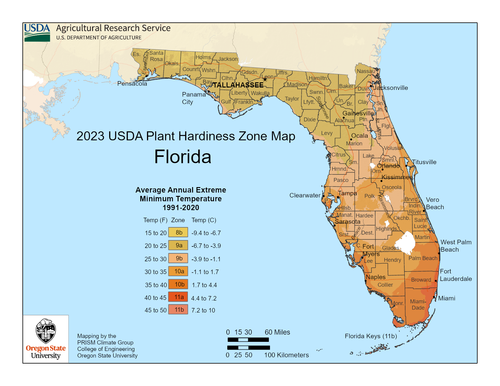 The USDA Hardiness Zones map shows the geographic range where you can expect certain groups of plants to thrive based on these characteristics. As global climate patterns shift in response to human activity, these hardiness zones can also be expected to shift and change. These shifting hardiness zones have vast implications for the diversity and composition of species in natural areas and in the built environment.
The most recent update to the map (November 2023), which is evaluated every 10 years, shows significant zone changes for most of peninsular Florida. In Manatee County, where the majority of the geographic area was 9a-9b, we now see 10a-10b (along the coast). Even some areas near Orlando are now in the 10a-10b range.
What does this mean for your landscape?
As a result of this change, we will no longer recommend certain plant species whose range has historically been more temperate. Some tropical species that were not recommended will now be recommended for use in home landscapes. For our northern neighbors just moving to Florida, this will mean that you certainly will not be growing Hostas. A specific example is River Birch, Betula nigra, a moderate sized tree commonly used in landscapes. This tree has a range from zones 4-9, since the majority of Manatee County is now 10a, this tree would no longer be a suitable recommendation. An alternative tree might now be a Mahogany, Swietenia mahagonii, a tropical tree ranging from zones 10-11, which only previously would have been recommended for south Florida.
To see the new USDA Hardiness Zone Map, visit: planthardiness.ars.usda.gov
Contact me at alyvinson@ufl.edu with questions or planting recommendations.
 10
10
