by Jessie Moses and Savanna Barry
We are in the dog days of summer and with price of gas these days, exploring the coast from the comfort of home can be a great option. We are excited to announce two new virtual options to explore and learn about recent habitat protection projects from the Nature Coast Biological Station. Read on for more about these cool new products. The first is an interactive Story Map that gives you a bird’s eye view of seagrass scarring in Crystal River. The second is a series of 360 tours of living shorelines over time in Cedar Key.
Saving Seagrass from Scarring — an interactive story
Seagrass is not your ordinary, run-of-the-mill grass. Healthy seagrass beds improve water quality, create habitats for countless organisms, and are crucial to Florida’s fishing industry and economy. In fact, about 70% of fish species in the state spend at least part of their life cycle in seagrass communities!
 Unfortunately, boaters can cause physical damage to seagrass beds as they putter over shallow waters, and propellers damage or disturb seagrass below. These actions can leave visible scars, areas with no vegetation, when the boat’s hull or motor causes injury to the seagrass leaves and stems or the complex root systems.
Although seagrass is present around the state near coastlines, the damage is considerable in high-traffic areas, including urbanized areas and marinas.
Never fear because there are simple solutions that boaters and non-boaters alike can make happen today! We created an interactive article to share how seagrass meadows benefit the marine ecosystem and the current issues they face.
Click here to view the StoryMap and learn how you can play a part in protecting seagrass communities.
Explore living shoreline projects in 360!
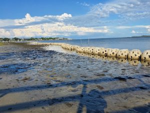
 Cedar Key’s coasts offer residents and visitors a chance to explore marine ecosystems and see incredible wildlife. In 2016, Hurricane Hermine swept through the area and eroded much of the shoreline in the Daughtry Bayou. After many discussions, meetings, and workshops, construction began in Spring 2020 to restore and enhance the G Street and Airport Road shorelines. Both locations are very close to residential and urban areas and have important species for the local and regional fishing economy!
These living shoreline projects were a collaborative effort between the UF/IFAS Nature Coast Biological Station, Florida Sea Grant, the University of Florida Soil, Water, and Ecosystem Science Dept., and the residents, county and city officials, and landowners of Cedar Key.
Visit the following links below to learn more about these living shoreline projects and travel through time from June 2020 to June 2022!
- G Street 360 tour
- Airport Road 360 tour
- Also available are 360 video tours on YouTube!
 0
0
