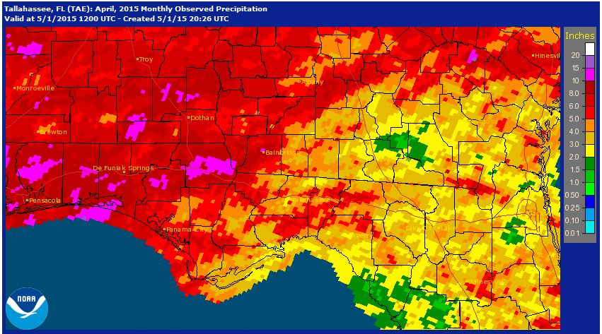
 If the old adage of “April Showers Bring May Flowers” is true, parts of the Panhandle should be a blooming mess very soon. The National Weather Service provides estimates of rainfall. The map above shows that there were some pockets in Escambia, Santa Rosa, Washington and Jackson Counties that received 10-15″ in April. In contrast, portions of Leon and Jefferson Counties received less than 3″ for the month. For much of the region the extra rain in April was a blessing, but wet fields have delayed planting for much of the peanut and cotton belt in Northwest Florida.
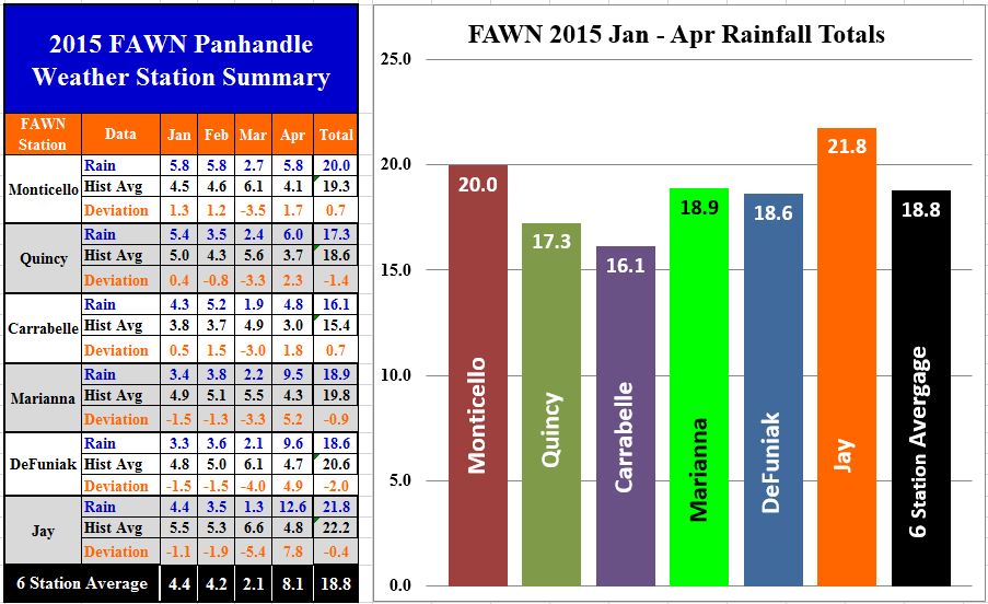 The University of Florida’s six Florida Automated Weather Network (FAWN) stations records show the variation that fell in the area as well. Through the first four months of 2015, the six stations averaged 19’6.” The Jay station has recorded 21.8″ for the year so far, with 12.6″ falling in April. Carrabelle was the driest location, with only 4.8″ for the month, and only 16.1″ for the year.
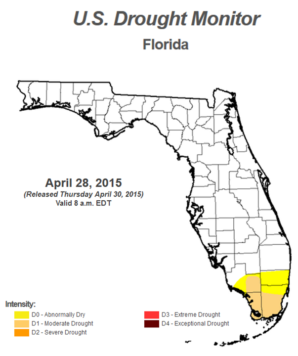 The good news is that the Panhandle is no longer included in the US Drought Monitor. The heavy rains that fell in mid-April have restored needed soil moisture to the region. Even so, four of the six FAWN Stations are still below historic averages for the first four months.
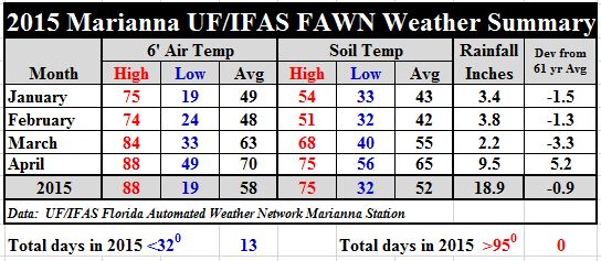 Temperatures in April seemed a lot warmer, but really it was a transition month with a fair amount of fluctuation. The average air temperature was up 7° as compared to March, and the soil was 10° warmer at 65°. But if you track the daily temperatures as seen in the chart below, soil temperatures rose and fell.
If you would like to see the complete historic monthly records, and the daily weather data recorded so far this year from the Marianna FAWN station, download: 2015 Marianna Jan- Apr Weather Summary.
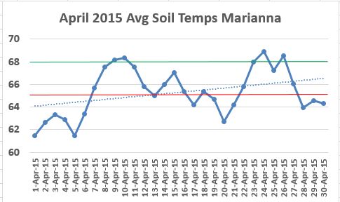
The green line, at 68°, represents the ideal temperature for excellent peanut and cotton seed germination. The red line at 65° is the minimum temperature for germination. The dotted trend line shows that the soil is warming up significantly, but the cold front that passed through at the end of April dropped soil temperatures down again. The National Weather Service forecast is predicting highs in the 80’s and lows in the 60’s from Monday on next week, so soil temperatures should be ideal for planting in the weeks ahead. As it works out, the wet fields that delayed planting may well have prevented poor germination from the cooler temperatures at the end of the month.
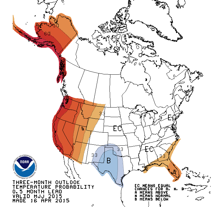
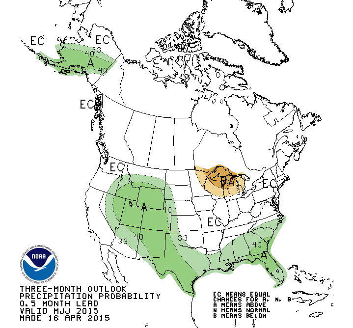 The Climate Prediction Center forecast for the next three calls for warmer than average temperatures and above average rainfall. Much of the anticipated above average rainfall comes from their El Niño climate forecast.
There is an approximately 70% chance that El Niño will continue in the Northern Hemisphere through summer 2015, and a greater than 60% chance it will last through autumn. CLIMATE PREDICTION CENTER
The weather so far in 2015, has not been so favorable for farming. Colder than normal temperatures slowed the growth of winter forages earlier in the year, as well as spring green-up of summer pastures, and wet fields are delaying crop planting, but if the forecasts hold true, conditions should improve rapidly for farmers and ranchers in the month ahead.
 0
0
