In a country like Jordan in the Middle East, where rainfall is scarce and water resources are severely strained, the agricultural sector is facing significant threats. From reduced crop yields to soil degradation, and growing water scarcity, farmers need to deal with limited access to irrigation and supplies, which puts immense pressure on both food production and rural livelihoods. Additionally, with climate change exacerbating these issues, the need for resilient, climate-smart agricultural practices is becoming critical for the region.
To help address these challenges in the country, GFSI (Global Food Systems Institute) faculty members and GFSI STRIKE Force and UFIC Partnership Development winners, Dr. Nargiza Ludgate, Dr. Greg Kiker, Dr. Rafael Muñoz-Carpena, and Dr. Gerrit Hoogenboom teamed up with Jordanian experts to hold a workshop designed for researchers, professionals, and graduate students interested in modeling climate-smart food systems.
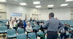
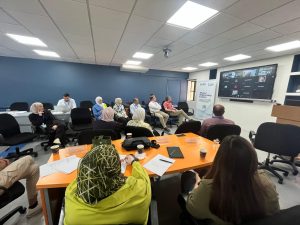
The workshop was held at the Water Diplomacy Center of the Jordan University of Science & Technology (JUST) in Irbid, Jordan from May 19th to May 21st of 2024. Participants came from several UF’s partner institutions in Jordan including JUST University of Jordan, National Agricultural Research Center, Yarmouk University, and Zarqa University. The Jordanian committee included a diverse group of professionals representing climate scientists, agricultural engineers, water engineers, statisticians, social scientists, and practitioners. This workshop was supported by the U.S.-Jordanian Higher Education Network program RAWABIT.

The event introduced participants to various modeling tools, such as the CUENCA hydrologic model to evaluate sustainable intensification practices within a system, G-Range and L-Range for rangeland simulations, Decisions under Conditions of Uncertainty by Modeled Agents (DECUMA) to simulate nomadic and sedentary agro-pastoralist populations, and the Decision Support System for Agrotechnology Transfer (DSSAT) for crop production. Participants also discussed and became aware of research funding opportunities within and outside Jourdan, such as the Fulbright programs for Jordanian scholars, IREX program for higher education, etc.
Why are these collaborations and
partnerships important for science?
Events like this workshop illustrate the critical role that international collaboration can play in advancing science and addressing global challenges through international collaboration. Issues like climate change, water scarcity, and food security are commonly exacerbated by global events and they do not recognize borders, languages, or cultures. By creating partnerships between countries with different areas of expertise or facing highly specific or complex challenges, we can create pathways to share knowledge, technology, and expertise that benefit both parties.
For UF researchers, engaging in these initiatives allows their research frontiers to expand by applying locally developed technology and knowledge in real-world environments different from domestic conditions, creating opportunities to refine, improve, or just test these tools to use them in broader applications.
In this case, by collaborating with a country like Jordan, UF researchers can gain insights into diverse agricultural practices developed under significant differences in abiotic and climatic conditions. For example, Jordan’s annual precipitation ranges from 4 – 14 inches of rain, while the state of Florida receives an average of 54 inches a year, and in hurricane-like events, some spots can get 20 inches in just a few days!
For Jordan, these workshops can provide access to advanced tools and training that may otherwise be out of reach or limited to just a few people. By learning from leading experts, such as the faculty team from GFSI, local scientists can adopt state-of-the-art methods and tailor them to their local environmental and socio-economic conditions.
Transferring and sharing this knowledge promotes local capacity-building, and empowers scientists, farmers, and policymakers to use advanced tools to make informed decisions, and implement more sustainable solutions to improve food security, water management, and climate resilience in the country.
What do these models do and why are they important for Jordan? Let us dig in:

Models covered
CUENCA watershed model
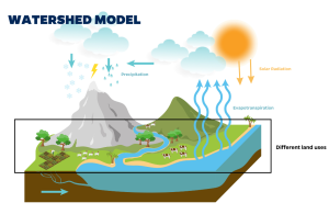
The CUENCA watershed model is a tool developed here at UF Agricultural and Biological Engineering Department (ABE). It is designed to help researchers better understand and manage water resources in regions, where water scarcity is a critical issue, like Jordan. It allows scientists to simulate how water moves through different parts of a landscape, including rainfall, runoff, groundwater flow, and how water is retained in ponds and wetlands. The model is structured like a network of “links and nodes,” with nodes representing key points, such as the outlets of smaller sub-areas within a larger watershed, and links representing the processes occurring in those areas.
One of the model’s main strengths is its ability to answer “what if” questions. For example, what if there is a significant decrease in rainfall? What if extreme weather events become more frequent, as projected by climate change models? The CUENCA model helps scientists simulate these scenarios and forecast their effects on the water availability and ecosystem health of the region.
For this workshop, UF/IFAS Distinguished Professor Dr. Rafael Muñoz-Carpena illustrated a use-case scenario of the model in a savanna ecosystem in Laikipia, Kenya. In this example, the model was used to link land use types and best agricultural sustainable intensification practices by showing how land use practices upstream (like farming) affect water flow and the environment downstream. This makes it a valuable tool for planning sustainable agricultural practices and ensuring the health of ecosystems in water-scarce regions.

G-Range and L-Range
These are two models specifically designed to simulate and analyze rangeland ecosystems at two scales, global (G-Range) and local (L-Range). The models help researchers and decision-makers understand vegetation dynamics, management practices, and climate change impacts on these key ecosystems.
G-Range
As the name suggests, the G-Range model operates on a global scale. This makes it suitable for assessing rangeland dynamics and their responses to environmental changes across continents.
The model is able to simulate how different types of vegetation grow, compete, and interact with the carbon cycle while tracking carbon inputs (e.g., photosynthesis), carbon outputs (e.g., respiration, decomposition), land use management practices, and climatic and environmental factors (like precipitation, temperature, and CO2). This provides information into carbon sequestration potential, climate change response, soil dynamics, and water regulation.
This wide perspective allows for large-scale policy and management evaluations, for example, to analyze the effects of water management strategies across different regions on the same river basin, or at a greater scale, analyze the effects of climate change on the local rangelands.
L-Range:
The L-Range model analyzes variables and effects similar to those of the G-range but at a different geographical scale. L-Range is designed for finer-scale simulations of localized rangeland areas such as individual ranches, reserves, or specific ecological sites which allows the model a high-resolution and more detailed analysis.
These two models can complement each other providing decision-makers with high-definition environmental analyses at different geographical scales, ensuring that the rangelands are properly and sustainably managed.
Decision-making in the Context of Uncertainty and Multiple Objectives (DECUMA)
DECUMA is a model specifically designed to simulate human decision-making processes in the context of rangeland and pastoral systems. The model focuses on understanding how individuals and households make decisions about resource use, livestock management, and livelihood strategies under conditions of uncertainty and change.
This model is usually used in conjunction with models focusing on biophysical rangeland aspects like L-Range or G-Range. Scientists combine these two types of models to better understand how humans will behave, or respond to, biophysical changes in their local context over time and space (for example comparing the effects of distinct types of land uses across different seasons).
Decision Support System for Agrotechnology Transfer (DSSAT)
The last one is very special for us here at GFSI. Even if DSSAT was not originally developed here at the University of Florida (UF), the model is managed by scientists from UF and the International Fertilizer Development Center (IFDC). The current leader of the DSSAT initiative is GFSI faculty member Dr. Gerrit Hoogenboom, who we recently interviewed to talk about the impact of using these models in developing countries.
DSSAT is a software system with a crop simulation model under the hood that makes predictions and has tools to prepare data to run the models. When you run a model, you need to input data, such as local weather, crop types, and others, and then the model predicts outputs. So, you need to analyze the outputs and then ultimately, the idea is to use the model’s outcomes to help farmers make informed decisions.” – Dr. Gerritt Hoogenboom
The DSSAT model is designed specifically to analyze and model the behavior of several types of crops under various environmental conditions like variable weather due to climate change and different management practices (crop rotation vs precision irrigation for example). The model can simulate variables like crop growth stages (when is the crop going to be ready to harvest), biomass accumulation (how much organic material the plants are storing and producing), yield (how big will the harvest be), and resource use (how much water and nutrients will the crop need).
By learning how to use these models, local Jordanian scientists and researchers can assist decision-makers, regional planners, and politicians in making well-informed decisions and implementing appropriate and sustainable management practices tailored to their local context and supported by science.
This is just one example of how our faculty members are using the funds that we provide at GFSI to make a global impact.
Thanks for reading and see you in the next one!
 0
0
