Like many of you, my head and heart have been wrapped up in the news of the devastating Texas floods along the Guadalupe River. A close friend’s son was evacuated from a boys’ camp on the river in the middle of the night. And my daughter works as a counselor for a summer camp on the Alabama coast, so I can easily visualize the fear and determination as those young counselors did everything in their power to take care of their beloved campers.
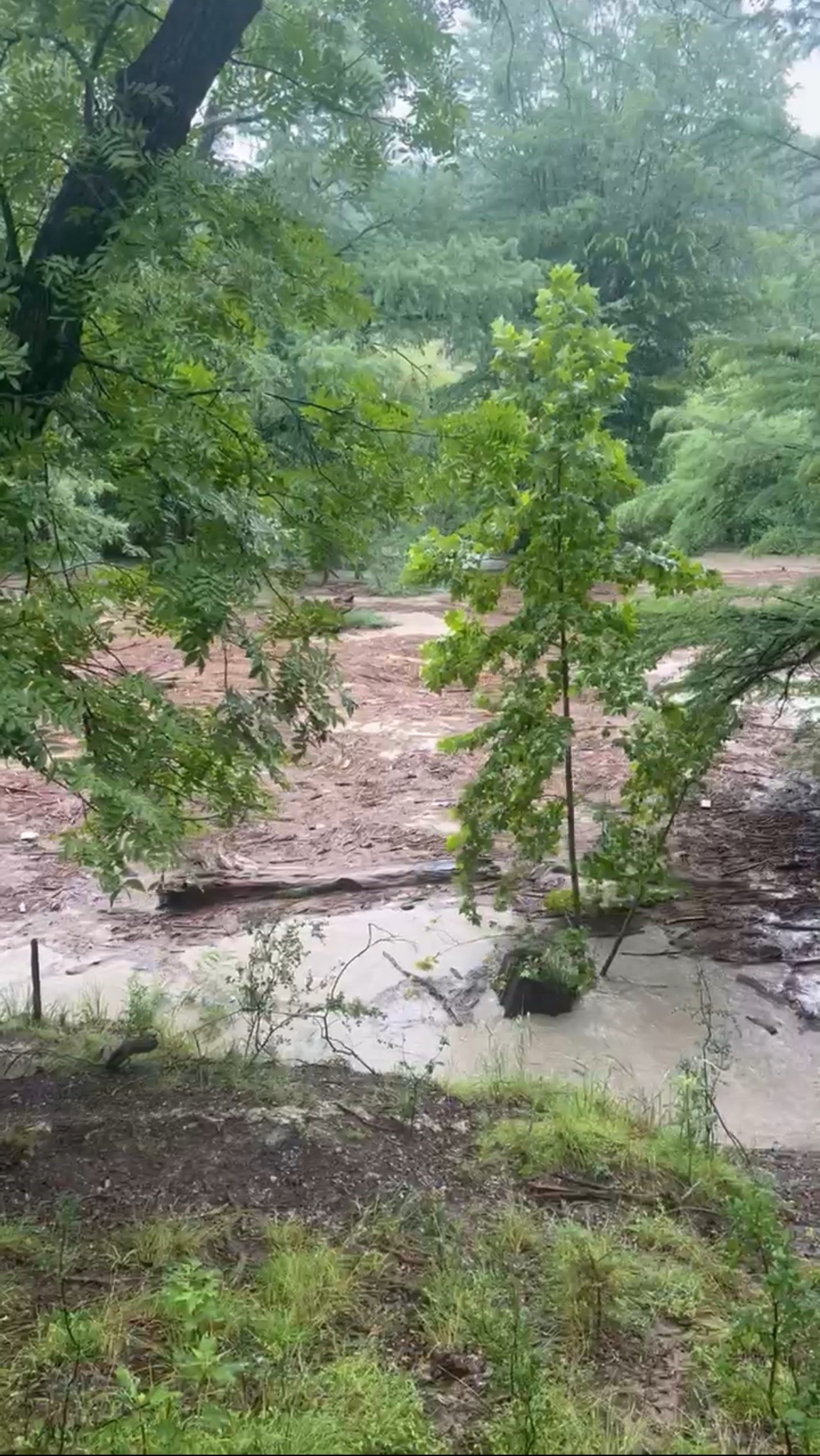
Kerrville and the surrounding towns along the Guadalupe River are at the heart of Texas Hill Country. Characterized by rolling limestone and granite hills, rivers, and eye-catching wildflowers (especially the bluebonnets), the area is beautiful and immensely popular. This geology, however, lends itself to flash flooding. While annual rainfall is relatively low, ranging from 15-30”, the deluge last week was associated with Tropical Storm Barry. This region’s proximity to the Gulf means heavy, intense rains are possible. In addition, the clayey, nonabsorbent soils are fairly shallow and underlain with limestone.

Therefore, if there’s a heavy rain, almost none of the rainfall is absorbed—especially if it comes down at a rapid intensity, high volume, and for an extended duration. The rainwater has nowhere to go but the nearest streambed, channeling down the rocky canyons to the larger river. This is how these 4th of July rains caused the Guadalupe to rise by 29 feet in just 45 minutes.
Flash floods are a part of life in many places, and we often experience them here around tropical storms. It’s not always in the summer, though—anyone who lived here in 2014 will recall the unexpected devastation from the record April rains that dropped 24” of rain in a day.
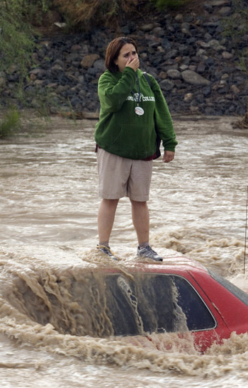
According to NOAA, “Flash floods are the number one weather-related killer in the United States.” The danger is encompassed in their name—they arrive in a flash, leaving little time to react. The only real way to avoid impacts is by staying on higher ground and protecting the floodplains—those wide lowlands that spread out on either side of a riverbed. During heavy rainfall and river flow, the banks overflow into these wetlands and absorb the floodwater.
Flash floods can be exacerbated by development, as well, even in areas that are not directly adjacent to water bodies. If wetlands and green spaces are built on or removed, the impacts of heavy rainfall can be more intense. With nowhere for the rain to absorb, it picks up velocity and depth. The impervious surfaces created by roads, parking lots, and buildings work just like those rocky Texas soils, channeling runoff to lower elevations with intense speed.

Flooding may be caused by dam breaches as well—if floodplains are no longer in place but dams or levees are built to hold back the water, devastation can follow if the dams don’t hold. Historic examples of this include the 1889 dam break in Johnstown, PA, with 2,200 killed, and more recently with the breaching of the levees in New Orleans that contributed to the loss of nearly 1,400 souls after Hurricane Katrina.
Debates on warning systems, timing, and lack thereof have already begun as the west Texas community reels from this devastation. It is imperative for those of us in hurricane and flood-prone areas to be aware of our flood zone and risk, and monitor weather reports and warning apps as severe weather approaches. NOAA has been actively developing and improving the Flooded Locations And Simulated Hydrographs Project (FLASH) since 2012, which was feasible due to funding that supported installation of high resolution sensors and accumulated weather data in a rapidly-changing climate. This video describes how FLASH uses the latest technology to predict flash flooding. While digital and high tech solutions are crucial, in this area nicknamed, “Flash Flood Alley,” it would also be wise to invest in locally controlled alarm systems akin to tornado sirens. These could warn people in the middle of the night, especially in a rural area with poor cell reception.
 11
11
