We continually make observations and extract patterns that we can use to predict the world around us. How things look, feel, smell, work. Science is the process we use to determine when those patterns are real and what causes them. Science is a structured inquiry that breaks down the phenomena we observe into parts that can be isolated and tested. Results of this testing are then subject to verification by other scientists. This approach – the scientific method – has led to much of what we experience in the modern world, from our cell phones to the food varieties we eat to the clothing we wear, the games we play, the medicine we take… up to superhighways and space stations.
Some phenomena, however, are composed of large-scale systems with many aspects and complex interactions. These systems can be analyzed in part, but to understand them and predict their behavior, they must be analyzed in their full complexity.
For example, in Florida’s agricultural areas, water is used intensively. Use of the water may be local, but the water itself is part of a system that involves the entire region. In the short term, weather patterns that stretch from the Pacific Ocean to the Sahara Desert may influence daily rainfall. In the long term, the amount of rain is a product of seasonal climate patterns, which are evolving with global climate change. Even in a rainy state like Florida, agricultural producers must irrigate their crops, which uses millions of gallons of water a day across the state. This water is usually drawn from deep underground in Florida’s aquifer, which is replenished by rain in states north of Florida. Florida’s communities also rely on this water, so the amount drawn for agriculture affects the amount available for communities. Once the water is used, it runs off agricultural fields, carrying fertilizers and pesticides, with regional impacts on natural water bodies and drinking water sources, further affecting communities in terms of recreation, fishing, clean water sources, etc.
How do we minimize agricultural water use while improving productivity in this complex and evolving system?
Meet Ziwen Yu
This is the type of problem that Dr. Ziwen Yu thrives on. An assistant professor in the Agricultural and Biological Engineering Department, Dr. Yu specializes in big data analytics. “Big data” refers to the mountains of information that can be collected through various means, ranging from ground-based sensors to satellite photographs, and the methods for collecting, managing, cleaning, filtering, and analyzing. These operations take high speed computers and sophisticated mathematical techniques and software as well as solid knowledge of the underlying natural processes. Yu’s background as a data engineer and environmental engineer qualifies him on both counts.
In many ways, wireless technologies have created the era of big data. By eliminating the need for wires to transmit power or data, wireless technology has made sensor networks more common in agriculture. For example, cameras can deliver images of a rancher’s cattle throughout their range, providing data on the health, well-being, and location of the animals. Sensors installed across a field can monitor soil moisture and temperature and drive a smart irrigation system which only uses water when it is needed. Weather stations can measure temperature, relative humidity, wind speed, and more, providing better information to plan agricultural operations or respond to a weather emergency. Sensor networks like these can generate data for both daily operations and long-term observations.
Yu’s goal is to take these data and then process and analyze them and turn them into practical insights for agricultural producers. For example, soil moisture is related to weather patterns. Wireless soil moisture sensors can give insights into this relationship that can be further combined with data about crop management, such as fertilizer applications and yields, to give real insight into the effectiveness of a farmer’s management choices. Better management choices can reduce expenses for fertilizers and water and increase yield while reducing environmental impacts. In this way, the data – which may seem rather abstract – become very real benefits.

The word “combine” doesn’t exactly describe the sophisticated processing involved in taking data from different sources, separating good data from bad, bringing the data into a common framework, and analyzing for meaningful relationships. The volume of data involved creates a role for artificial intelligence, specifically, machine learning. In this type of computing, Yu can build a set of rules for the computer to follow in analyzing the data and then “train” the computer by giving it data that are already known to be good and bad. The computer learns from this guided experience, but it learns in such a way that it can apply the rules to new data. With machine learning, the more data the computer processes, the more accurate it becomes.
Yu is an expert at building these systems and in the mathematical and statistical methods used in their analyses. His most recent work has focused on issues related to climate change. One of the impacts of climate change is a changing pattern of where rainfall events occur and how intense they are. This has important implications for the management of runoff in both agricultural areas and in urban ones. Models of precipitation are fundamental to understanding the impact of rainfall events in general and the broader patterns of weather over time and location, which is climate.
Better Models of Rainfall
Rainfall is often modeled statistically, and this is a common and useful approach, but it is not necessarily linked to the actual physical processes that cause rainfall, such as the amount of moisture in the air, the temperature, and the pressure. In all his work with modeling, Yu is concerned to connect the modeling to these physical processes and to make the results of modeling more intelligible to users of these results. Yu’s goal is to help agricultural producers discover and benefit from the results of data-driven methods and artificial intelligence, which producers have been slow to adopt. Yu finds that reliability and interpretability of results are key issues in this reluctance.
For example, Yu was interested in going back to basics and looking at how pressure changes can predict extreme rain events. Falling pressure is characteristic of these events, but it has not been widely studied in connection with predicting them. Yu and colleagues examined extensive weather data collected by the National Centers for Environmental Information (NCEI) and the Florida Agricultural Weather Network (FAWN) from their statewide sensor networks. These data provide a continuous record of pressure for many locations in Florida. Yu isolated periods of decreasing and increasing pressure and correlated these with measured rainfall. He and his coworkers found that decreasing pressure was well associated with increasing chances of rainfall as well as rainfall intensity. This work provides a physical basis for further modeling and one that can be tied to a directly measurable property of the atmosphere anywhere in the world (for example, by the weather stations mentioned above).
Yu led a team that used this work to improve rainfall simulation. Combined with other statistical methods, Yu and colleagues generated a 100-year series of hourly precipitation simulated for the northeastern U.S., which indicated drier summers and warmer winters for that region, agreeing with several other projections, but grounded in the physics of precipitation.
Soil Moisture Is Key
In related work, Yu used the results of his rainfall and climate modeling to create a more realistic analysis of data being delivered by soil moisture sensors. The moisture in the top three feet of soil is referred to as root zone soil moisture (RZSM), and it is highly variable over time and space but critical for irrigation planning. Farmers usually adopt irrigation schedules that guarantee a certain amount of water delivered, often overwatering in the process and increasing freshwater losses and environmental impacts.
Satellites can provide some information that is partially helpful for irrigation scheduling because it only senses moisture in the topmost soil layer and only provides values at 2- to 3-day intervals averaged over several square miles. What is needed is information on the entire root zone – up to a yard deep – at daily intervals at least and averaged over a few acres at most. In-ground soil moisture sensors can provide the depth information needed at a frequency of several times a day, but that information applies to a very limited area. Yu finds the solution to this problem by integrating satellite and ground sensor information.
In projects that focus on vegetable crops with shallow root zones, Yu is developing statewide root zone soil moisture maps. The maps use machine learning to integrate satellite date, sensor data, and methods of assuring data quality. Through a variety of methods, Yu plans to validate these maps, for example, investigating how soil moisture changes with different irrigation and fertilization protocols and under various environmental conditions. To accomplish this, a multidisciplinary team of experts from the University of Florida, Auburn University, and the University of Georgia will collaborate on experiments in the fields of six participating producers. This work will yield many products that will be publicly available and useful to farmers throughout the three states.
Farmers and Data
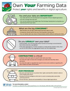
For Yu, all this work with big data raises another important question: who owns the data? When a producer participates in a study to develop a new tool that powers irrigation scheduling – a tool that thousands of producers may benefit from and one that many companies may profit from – what are the rights of the producer? As a researcher actively developing such tools, Yu wants to investigate the relationship between farmers and companies that provide smart agricultural technologies to establish fair data rights. This effort has brought together a group of faculty and extension agents of different backgrounds, including precision agriculture, soil science, extension, social science, big data, and law. The group has been meeting regularly since early 2020 to consider the perspectives of all stakeholders.
In a case of the problem becoming the solution, Yu can use advanced computing methods, such as natural language processing and neural networks, to examine contracts between farmers and technology companies.
The idea of intellectual property rights for farmers regarding data collected from their property is a new one that is not really covered by existing law governing intellectual property rights. Copyright law and trademark law originally applied to physical objects or marks, but they were extended in the 20th century to audio products and phrases, which as aural productions, that might not have a concrete form. Property in the purely digital realm, such as a data, take another step away from physical form. Who owns what in the modern world of technological innovation has become a tricky question.
In these and many other projects, Yu’s work with big data provides important insights into the physical environment and into the methods used to study it. His current work focuses on agricultural water use, the natural systems that support it, the management of runoff, and the methods to acquire, manage, and analyze data in these areas. Big data has become a scientific discipline within itself that is being used in many areas of science and engineering. What big data means in practical terms is the ability to examine larger systems in greater detail – exactly the tool needed to tackle the complexity mentioned earlier. As more researchers discover the power of big data for their specialty, Yu’s expertise will be called on repeatedly to develop appropriate applications.
That’s UF ABE: Big Questions, Global Reach.
This article was written by: Charles Brown
 1
1


