By: Lisa Krimsky, Betty Staugler, Brittany Scharf, Krista Stump and Rebecca Burton
Florida’s lingering red tide has left many concerned residents with unanswered questions. Over the past 14 months since the bloom began off the coast of Southwest Florida, residents have voiced concerns about fish kills, economic impacts and environmental damage. Mixed messages from a variety of sources has made this already difficult situation even more confusing.
Using up-to-date, science-based information, faculty with UF/IFAS Extension and Florida Sea Grant have written this blog post to answer some of the most frequently asked questions about red tide.
What is red tide?
Red tides are caused by an accumulation of a type of microscopic organism called a dinoflagellate, which is found in lakes, rivers, estuaries and the oceans. The particular dinoflagellate that causes Florida’s red tide blooms is Karenia brevis.
It’s important to note that not all red tides are caused by the same species, nor are all red tides always red. Most dinoflagellates are harmless though some, including K. brevis, can produce neurotoxins that can cause respiratory problems in humans and attack the central nervous systems of fish and other wildlife. It is for this reason that many scientists refer to blooms of K. brevis as harmful algal blooms (HABs) due to the impacts they can have on the environment, humans, and our coastal economies. Though HAB is the preferred terminology, this document includes the term red tide as it is recognizable to the public and media.
What causes red tide?
K. brevis blooms are exclusively initiated in the Gulf of Mexico where it is almost always present at low and harmless concentrations. Red tides are not uncommon and occur almost annually in the Gulf, particularly in the Tampa Bay to Charlotte Harbor region. The first scientifically documented red tide bloom in Florida dates back to 1844, predating extensive human development.
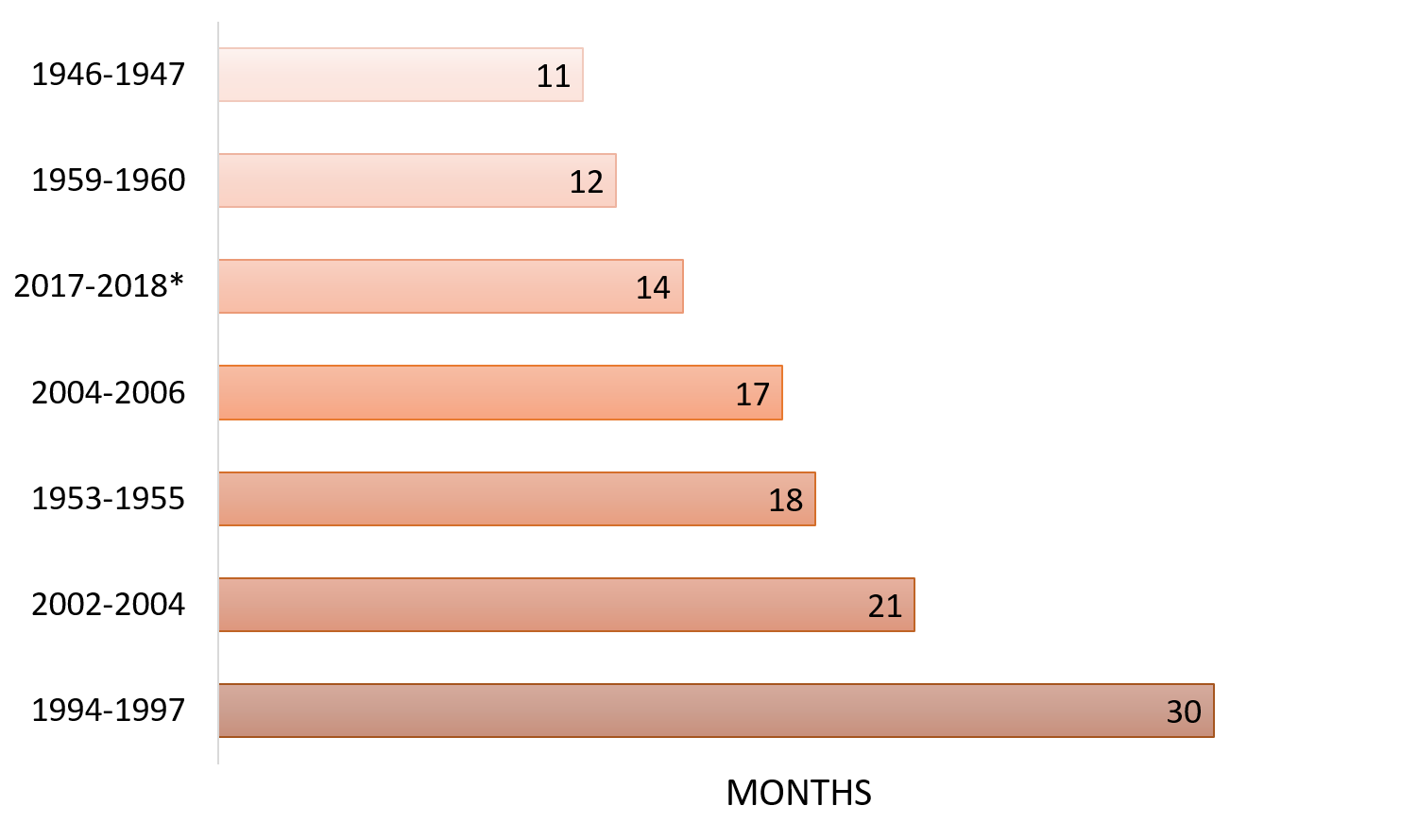
Florida’s red tides can appear throughout the year, though they usually peak late summer to early fall and can last from a few days to months. The current Florida red tide initiated in October 2017 and to date, is still present on the west coast (Figure 1). Since the Florida Fish and Wildlife Conservation Commission Fish and Wildlife Research Institute (FWRI) started monitoring red tides in 1954, only four previous blooms have lasted longer (Figure 2). Though, this one is still ongoing.
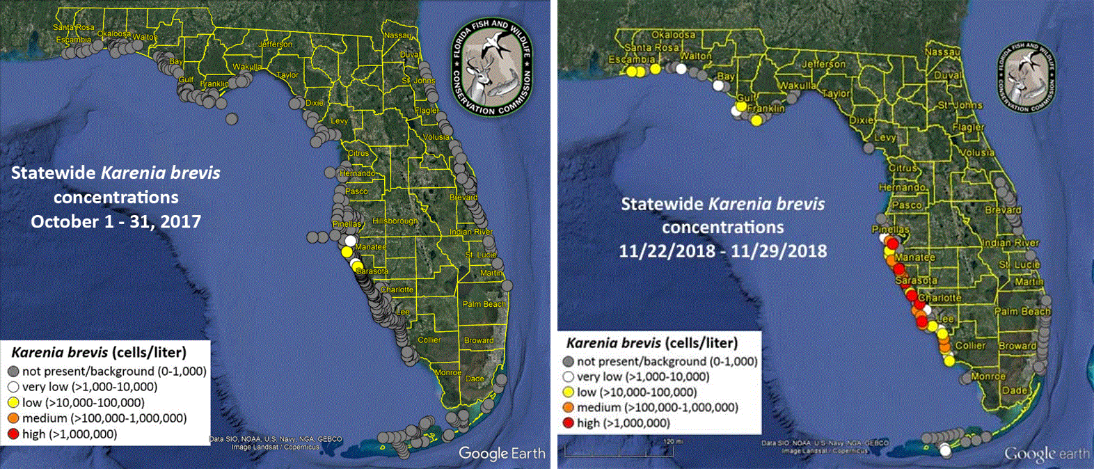
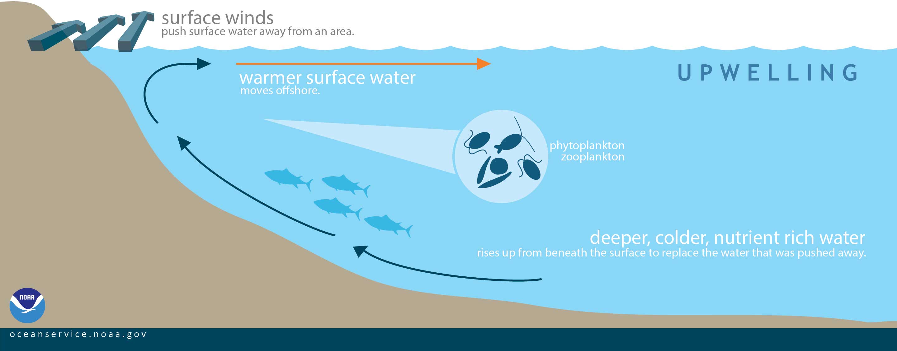
Red tide blooms originate naturally 10-40 miles offshore in the bottom waters of the Gulf of Mexico. K. brevis cells that hang out at the bottom are brought to the surface by a phenomenon known as upwelling, a process in which deep, cold and nutrient-rich water rises to the surface (Figure 3). Winds and ocean currents then bring the bloom inshore where it has an impact on our coasts.
K. brevis, like all algae, requires three things to grow and survive: optimal light, temperature and nutrients, specifically nitrogen and phosphorus. The sources of these nutrients vary among the offshore, nearshore, and estuarine environment. Nutrient sources also vary spatially, or north to south. In other words, nutrient sources in Sarasota may differ from those further south in Fort Myers.
K. brevis, unlike other phytoplankton species, can feed on a variety of nutrient sources, in a variety of forms. For this reason, it is impossible to link a red tide bloom to one particular source of nitrogen or phosphorus.
While offshore, a small bloom of K. brevis can begin by using the nitrogen produced by the nitrogen-fixing algae, Trichodesmium. This is because Trichodesmium can “fix” nitrogen or obtain it from the atmosphere and convert it to a form that is useable by K. brevis. Other sources of nutrients in the offshore environment include zooplankton and microplankton excretion, grazing food waste, and benthic flux (the exchange of nutrients from the sediment to the water).
Once the bloom moves nearshore, nutrients associated with decaying red tide and fish kill biomass are among the most significant nutrient sources for blooms. So much so, that red tide has been considered nearly self-sustaining. Nearshore red tide blooms can also obtain nutrients from air pollution (atmospheric deposition), releases from rivers and estuaries, and estuarine flux (the exchange of nutrients to and from the estuary).
When the bloom makes its way inshore, it feeds on excess nitrogen and phosphorus coming from various nutrient sources along the coast including stormwater, fertilizer runoff, septic tanks, and/or faulty wastewater systems. Scientists say these excess nutrients play a role in the extent and duration of large bloom events like the ones we are currently experiencing on both coasts.
If the bloom originated in the Gulf, why is it also on the east coast of Florida?
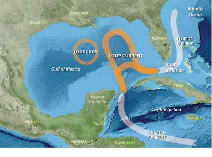
One thing that makes this year’s bloom unique is its presence on the east coast of Florida. Since 1953, there have been only eight other reported blooms on the east coast. Scientists hypothesize that in early October 2018, red tide cells in Monroe County got picked up and transported by the Florida Loop Current to the east coast (Figure 4).
When will the red tides end?
The duration of a bloom is dependent on a variety of chemical, physical and biological factors such as available nutrients and sunlight, temperature, wind, predation by zooplankton, and competition with other species. Therefore, it is hard for scientists to predict when blooms will end.
What are the impacts of a red tide?
K. brevis is considered harmful because it produces a variety of natural toxins, the most important of which are the neurotoxic brevetoxins. Through inhalation, direct contact or ingestion, these toxins, in high enough concentration, can harm and kill fish, birds, and marine mammals. The current red tide has resulted in serious impacts to fish, marine mammals, marine birds, residents and coastal businesses. These types of impacts are typical during severe red tide events. However, more fish have died during this red tide in Lee and Charlotte counties compared to past severe red tide events, and it’s not over.
In addition to the impact to sea life, red tides can have human health impacts. Exposure to brevetoxins occur through inhalation or ingestion. K. brevis cells are weak, so wave action can break open the cells, releasing the brevetoxins as an aerosol. People in coastal areas can experience varying degrees of eye, nose, and throat irritation. Beach-goers experiencing respiratory irritation are advised to leave the beach or go to air conditioning and symptoms will usually go away. Some people who come in contact with water or sea foam with severe red tide may experience skin and eye irritation, including rashes (Table 1).
K. brevis can cause serious illness to people with severe or chronic respiratory conditions such as asthma or emphysema. For example, red tide can trigger asthma attacks and susceptible populations may experience chronic pulmonary symptoms, even after leaving the area. During severe red tide events, brevetoxins can be detected 1-2 miles inland from the beach. For these reasons, at-risk populations are cautioned to avoid coastal areas with active red tides.
Red tides can also result in significant economic impacts. Economic costs are associated with four main sectors: recreation and tourism, commercial fisheries, public health, and monitoring and management costs. There is also the potential for a decline in residential home value due to red tide, though these costs have not been examined.
- Red tides are estimated to cause more than $20 million in tourism-related losses in Florida each year.
- The 2015-16 red tide event resulted in a sales loss of $1.33 million to the hard clam aquaculture industry.
- Health costs attributed to medical expenses and lost work days associated with HABs cost the United States $22 million dollars annually. According to the Florida Department of Health, treatment of respiratory illness in Sarasota County during the 2015-16 red tide event averaged $0.5 to $4 million dollars.
- Clean-up costs associated with the disposal of millions of tons of dead fish and marine life has been estimated to be nearly $163,000 annually (1998 dollars) for Florida. However, severe events such as the current one can be significantly costlier where totally cleanup costs for all affected areas can reach in the millions of dollars.
Is it safe to eat locally caught seafood when there is a red tide?
Whether or not seafood is safe to eat during a red tide is dependent on the type of seafood being consumed and where it was harvested from.
Filter-feeding bivalves such as clams, oysters, and mussels can accumulate K. brevis toxins in their tissues, though there is no evidence that they are susceptible to the toxin themselves. The brevetoxins are tasteless, odorless and are not destroyed by cooking. Commercially available shellfish is safe because it is harvested from areas that are monitored by the Florida Department of Agriculture and Consumer Services (FDACS), Division of Aquaculture (http://www.freshfromflorida.com/Divisions-Offices/Aquaculture). Recreational shellfish should only be consumed if they are collected from open harvesting areas.
Shellfish harvesting areas undergo a precautionary closure when red tide cell counts exceed 5,000 parts per liter and are no longer safe for human consumption. Consumption of these toxins can cause Neurotoxic Shellfish Poisoning (NSP) in humans and result in the rapid onset of gastrointestinal symptoms and/or neurological symptoms from minutes to hours after eating the contaminated shellfish. No fatalities have been attributed to NSP to date.
Shellfish require approximately two to six weeks to purge the toxins from their tissues, though this can vary greatly. Once a red tide event has dissipated to less than 5,000 cells per liter, shellfish meat samples are tested for toxicity before harvesting areas can be reopened.
Like oysters and clams, scallops are bivalve molluscs that filter tiny particles from the water column for food. During red tide blooms, the toxins produced by K. brevis are also filtered by the scallops and accumulate in their gut. Scallop harvest zones are managed by the Florida Fish and Wildlife Conservation Commission who will close certain scallop harvest areas in response to red tide blooms. Scallops are safe to consume if they are harvested from open scallop harvesting areas during a red tide bloom. However, it is recommended that only the white muscle, and not the whole organism, be consumed.
Other shellfish, such as crabs, shrimp, and lobsters, as well as local finfish are generally safe to eat during red tide blooms because they do not accumulate the toxins in their muscles. However, just like scallops, red tide toxins can accumulate in the guts of finfish or the hepatopancreas (tomalley) of shellfish so these parts should be discarded. In addition, animals found dead or distressed in red tide areas should never be eaten.
Can we stop red tide blooms?
Currently there is no effective way to stop a red tide bloom without potentially causing harm to the overall ecosystem. The harmful effects we experience occurs when red tide toxins are released as the K. brevis organism dies. As such, potential controls would need to kill the K. brevis organism and remove the toxins from the water — all without causing harm to the ecosystem.
Red tides may be as large as 10,000 square miles – and they occur throughout the entire water column, making irradiation impractical. However, scientists from Mote Marine Laboratory and Woods Hole Oceanographic Institute are currently studying methods to control and mitigate red tide in localized areas such as dead-end canals and small embayments in red tide-affected coastal communities.
Is there a connection between the red tide and the blue-green algae blooms?
Nutrients from the natural flow of fresh waters along the coast of Florida have always had a probable influence on the extent of red tide. It is possible that the freshwater releases from the Caloosahatchee River and Estuary which support the blue-green algae also feed red tide. What scientists do not currently know is how or if the red tide and blue-green algae organisms interact with one another. This is an important topic that needs further research.
K. brevis is a saltwater species and cannot grow in low salinity waters. Microcystis, the dominant blue-green algae occurring this year in Lake Okeechobee is a freshwater algae and cannot survive in higher salinity waters. Because they have different salinity tolerances, these two species are not well suited to coexist. Determining potential connections between these and other algal species requires an understanding of the fate of nutrients and any toxins after cell death. Scientists are investigating this and other questions related to these blooms.
For additional information about the differences between red tide and blue-green algae blooms, please refer to:
https://blogs.ifas.ufl.edu/osceolaco/2018/08/08/harmful-algal-blooms/
https://www.flseagrant.org/news/2018/08/understanding-the-florida-red-tide/
Who monitors red tides?
Many groups of scientists and volunteers work together to monitor and research harmful algal blooms throughout the year regardless of a bloom’s presence.
Water samples are collected from over 100 locations throughout Florida on a weekly, bi-monthly, or monthly basis through partnerships with state agencies, county governments, and citizens. Collection sites are sometimes randomly selected by those conducting the sampling or taken from pre-selected locations that are visited frequently.
The water samples are taken from the shore, bridges, piers, and by boat to track what is going on along the coast as well as in offshore waters where red tide originates. This allows the FWC, the agency who is provides regular updates on the status for the state of Florida, to cover a large area efficiently, effectively and in a timely manner at a low cost. Once the water samples are collected, they are shipped to FWC’s Fish and Wildlife Research Institute for processing. Each sample is individually scanned for the presence of three harmful algal bloom species: Karenia brevis, Pyrodinium bahamense, and Pseudo-nitzschia spp., with other toxic spp. noted.
Where can I find up-to-date information?
During periods of non-red tide blooms, full reports are posted each Friday by 5:00 PM EST on FWC’s Red Tide Current Status page (http://www.myfwc.com/research/redtide/statewide/).
The report is broken down by region and outlines the compiled data in both chart and map formations. Each chart details the location and date that the water sample was taken, the concentration of red tide cells present, and the agency responsible for collecting the sample. The interactive Google Earth map is a more visual approach of the same information included in the chart report. Samples are displayed by location and are color coded based on the concentration of red tide cells that were detected.
Additional information about the sample is provided when the color-coded dot is clicked on. When available, a satellite map can be overlaid on the Google Earth map; however, during times of heavy rains the satellite maps are unavailable.
When a red tide is in bloom, additional reports in the form of interactive maps are provided by 5:00 PM EST daily on FWC’s website (http://myfwc.maps.arcgis.com/apps/View/index.html?appid=87162eec3eb846218cec711d16462a72).
Additionally, an interactive map produced by the University of South Florida’s College of Marine Science Ocean Circulation Group, models the transport of the bloom at the surface and at the bottom of the water column. This interactive map allows visitors to click on their area of interest and view the best prediction of where the red tide is headed on the West Florida Shelf (http://ocgweb.marine.usf.edu/hab_tracking/HAB_trajectories.html). The starting point of each trajectory is depicted by an “X” and is followed by a squiggly line of where that water will be headed over the next three days. Each trajectory is color coded using the same cell category concentration as the FWC interactive maps.
Harmful algal blooms are also tracked at the federal level. The National Oceanic and Atmospheric Administration (NOAA) has multiple sites for red tide information.
Cell counts and bloom status reports are available through the Harmful Algal Blooms Observing System (https://service.ncddc.noaa.gov/website/AGSViewers/HABSOS/maps.htm) and NOAA issues twice weekly forecasts (https://tidesandcurrents.noaa.gov/hab/gomx_condition.html?region=swfl) that allow us to monitor ongoing blooms and provides a forecast for the level of respiratory irritation by region.
In addition to these reports, you can also visit a website to keep up with local conditions before you head out: https://visitbeaches.org/. This collaboration between the University of South Florida and Mote Marine Laboratory assists the Fish and Wildlife Conservation Commission with providing the public with information regarding respiratory irritation and fish kills associated with the red tide blooms. Citizen scientists can also participate in the collection of this data by reporting the current conditions to 1-941-BEACHES.
Conclusion
Red tide blooms have been scientifically documented in Florida for nearly two centuries and we can expect them in the future. While the prevalence of these blooms predates human influence, it is likely that human activity has played a role in fueling current blooms. Floridians are accustomed to these “natural events,” but the impacts are also becoming more pervasive. If Florida is to progress in a safe and economically viable future, Floridians must address our contribution to the problem by reducing our nutrient inputs and supporting research to further understand red tide causes, impacts, and mitigation strategies.
Resources:
Adams, C., “Red Tide Causes Economic Losses to Southwest Florida Industry”. UF/IFAS Florida Shellfish Aquaculture Featured News. January 13, 2017. http://shellfish.ifas.ufl.edu/news/red-tide-causes-economic-losses-sw-florida-industry/
Anderson, D.M., Hoagland, P., Kaoru, Y., and A.W. White. 2000. “Estimated Annual Economic Impacts from Harmful Algal Blooms (HABs) in the United States”. Sea Grant Woods Hole Technical Report. WHOI-2000-11.
Florida Fish and Wildlife Conservation Commission Fish and Wildlife Research Institute. “Red Tide”. http://myfwc.com/research/redtide/. Accessed: October 15, 2018.
Florida Department of Agriculture and Consumer Services, Division of Aquaculture. 2017. “Background and Monitoring Program for Florida Red Tide. FDACS-P-00080, Technical Bulletin #01.
Heil, C.A., Dixon, L.K., Hall, E., Garrett, M., Lenes, J.M., O’Neil, J.M., et. al. 2014. “Blooms of Karenia brevis (Davis) G. Hansen & Ø. Moestrup on the West Florida Shelf: Nutrient sources and potential management strategies based on a multi-year regional study.” Harmful Algae 38, 127-140.
Kirkpatrick, B., L.E. Fleming, D. Squicciarini, L.C. Backer, R. Clark, W. Abraham, J. Benson, Y.S. Cheng, D. Johnson, R. Pierce, J. Zaias, G.D. Bossart, and D.G. Baden. 2004. “Literature review of Florida red tide: implications for human health effects.” Harmful Algae 3(2): 99-115.
Kirkpatrick, B., Pierce, R., Cheng, Y.S., Henry, M.S., Blum, P., Osborn, S. et. al. 2010. “Inland Transport of Aerosolized Florida Red Tide Toxins”. Harmful Algae 9, 186-189.
Weisberg, R.H., Zengh, L., Liu, Y., Corcoran, A.A., Lembke, C., Hu, C., Lenes, J.M, and J.J. Walsh. 2016. “Karenia brevis blooms on the West Florida Shelf: A Comparative study of the robust
 0
0
