Welcome to the third blog of the Florida 101 series. If you haven’t read them yet, go back and check out our other entries on Florida weather and tides.
Although it is definitely not on anyone’s list of favorite things about living in Florida, hurricanes are part of life in a tropical, coastal state. It is important to understand what hurricanes are and how to prepare for them. As we approach the peak of hurricane season, it is a good time to review hurricane basics and emergency plans!
What is a hurricane?
A hurricane is a tropical cyclone – a low-pressure weather system that rotates. A tropical cyclone is considered a hurricane once it reaches 74 mph of sustained winds or higher. First the system is considered a tropical depression (less than 39 mph winds), then it may become a tropical storm (winds between 39-73 mph), and finally once it reaches 74 mph it is considered a hurricane.
Hurricanes can then be classified as categories 1-5 based on the maximum sustained winds. Once you get to a category 3 hurricane (111-129 mph), it is considered a “major hurricane” with the likelihood for devastating damage. However, these scales are only related to the wind speed, and do not take into account the effects of extreme rain, tornadoes, or storm surge, which can come with storms of all wind strengths. All hurricanes need to be taken seriously, as a storm of any category and size can cause damage to homes, downed trees, and flooding.
What does a hurricane need to form?
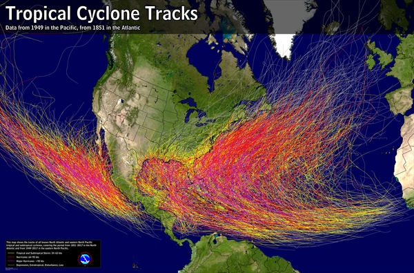
Hurricanes require warm water (at least 80 degrees) and moist air to form. Hurricanes form when there is an area of low pressure. This warm, less dense air rises, and then more moist air is drawn in across the surface of the ocean to fill that space. They also need low vertical wind shear – this means the speed and direction of the wind is similar close to the ground and high up in the atmosphere. Finally, hurricanes can only form far enough from the equator that they feel the Coriolis affect, which is what causes hurricanes to spin. This effect doesn’t exist at the equator, which is why you see the empty area within 5 degrees north and south of the equator when you look at tracks of hurricane maps!
Because of Florida’s location along the warm waters of the expansive Atlantic Ocean, it is the state most affected by hurricanes. You can research historical hurricane data in your area through the NOAA’s Historical Hurricane Tracks website. However, even if a storm has not hit your area in the past, that is not a guarantee it will not hit in the future.
What is storm surge?
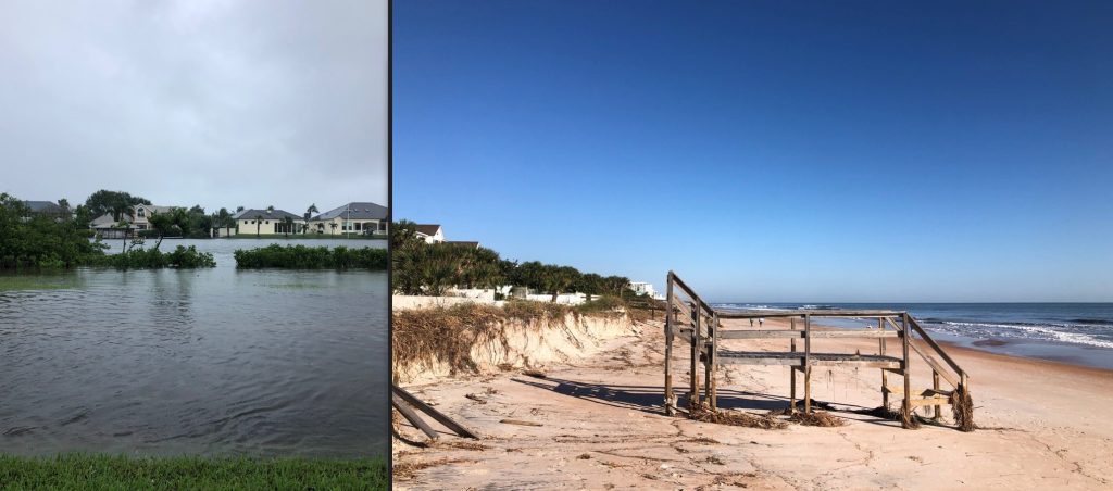
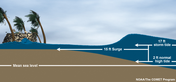
Other than wind damage, one of the biggest threats of a hurricane is storm surge. Storm surge is an abnormal rise of water generated by a storm’s winds blowing onshore. Storm surge is typically higher on the gulf coast than the Atlantic because the gulf has a more shallow depth and the water gets pushed into a contained area. Nevertheless, both coasts can experience storm surge from hurricanes and tropical storms.
If a storm has a predicted 4 feet of storm surge, the water level will be 4 feet higher than the normal water level at that time. The water level can also be affected by the tides. The term storm tide refers to the combination of storm surge and astronomical tide because of a storm. Unfortunately, we already have our highest tidal ranges of the year during the late summer, so when a storm hits during a spring tide (full moon or new moon) in the summer or fall, it can cause exceptionally high water levels at the beaches and also up into our rivers and estuaries that are connected to the ocean by inlets.
Storm surge can cause flooding of roads and properties. The National Hurricane Center’s Storm Surge Risk Maps allow you to see what areas of your coast are vulnerable to storm surge of various levels.
When is hurricane season?
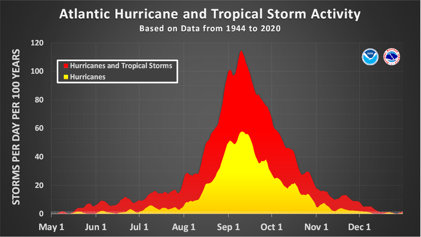
Hurricane season in Florida runs from June 1 – November 30. Most storms take place between the start of August and end of October; however, storms can also come before or after the official season so make sure you prepare early!
What should I do to prepare for a hurricane?
Dealing with a hurricane in Florida is not a matter of if, but when. Make sure you are prepared ahead of time! Visit NOAA’s National Hurricane Preparedness website for information to help you get prepared far ahead of storms as well as deal with storms when they hit. Some key tips to prepare before hurricane season hit are to:
- Develop an evacuation plan for yourself and your family.
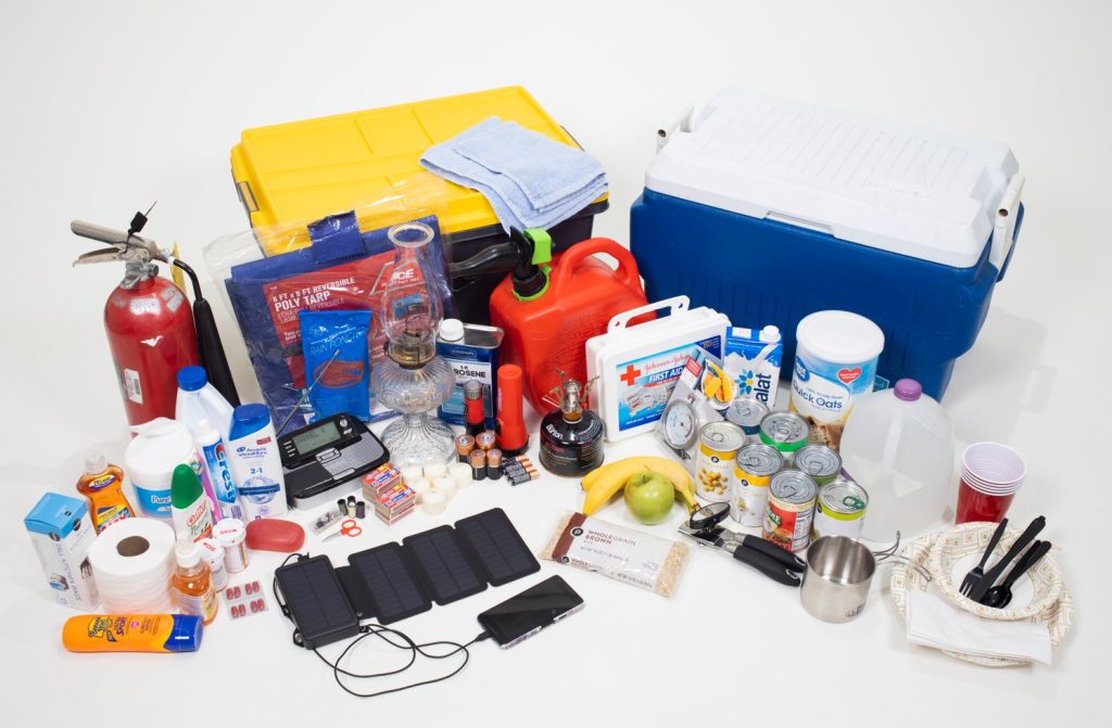
- Assemble disaster supplies, including food, water, batteries, charger, radio, and cash.
- Get an insurance checkup and document your possessions via a list and photos.
- Create a communication plan with a hand-written list of contacts.
- Know your evacuation zone and the information for your county’s emergency operations
Additional resources
Several of my colleagues at the University of Florida IFAS Extension have written blogs with more specifics on various types of hurricane preparation that you may want to check out:
- Disaster Preparation Resources From UF/IFAS Extension
- Are you Hurricane Ready? Creating the Ultimate Emergency Plan
- Hurricane Season: Preparing The Inside of Your Home
- Hurricane Preparation for Gardens – UF/IFAS Extension Pasco County
 1
1
