|
In the days after Hurricane Idalia made landfall, a brief camera sweep of the Cedar Key landscape gave a glimpse of hope for two viewers of The Weather Channel’s Jim Cantore, watching from their inland evacuation spots.
A stretch of beach, blanketed by green plants, came into view behind the meteorologist.
“It’s still there!”
Mark Clark, a University of Florida associate professor in the soil, water, and ecosystem sciences department, said he and colleague Savanna Barry, a UF/IFAS Extension regional specialized Florida Sea Grant agent, began texting back and forth after the sighting of one of their project sites.
Barry and Clark lead several outreach efforts from the UF/IFAS Nature Coast Biological Station (NCBS) in downtown Cedar Key, the same fortress that sheltered Cantore’s team during Idalia. One of their larger collaborations is a trio of “living shorelines” projects, a natural coastal resilience strategy first implemented in the small coastal community in 2017.
“This was the first big test for these living shorelines,” Clark said, explaining that 2016’s Hurricane Hermine was a driving force behind jumpstarting the projects. “We had no guarantees the plants would make it, let alone come out somewhat unscathed.”
As the 2023 hurricane season comes to a close, the living shorelines of Cedar Key should be considered one of the year’s success stories.
In the span of a few hours on Aug. 30, Hurricane Idalia brought a record storm surge to the tiny coastal town, and the water level peaked at 6.89 feet above the typical highest tide level, according to the National Oceanic and Atmospheric Administration.
But the shorelines largely thrived, with Clark and Barry collecting data that proved, among other highlights, that the installations reduced the wave energy coming ashore.
Even where the inundation of floodwaters damaged the natural barriers, new growth has already begun – echoing the resilience of the Cedar Key community these shorelines protect.
So, what is a living shoreline?
The name itself captures the intent of these natural coastal resilience installations: Marsh plants that are adaptable to the tidal highs and lows, sturdy mangroves, upland grasses typically seen on sand dunes across Florida, and even offshore structures that attract oyster colonization.
“The goal of these living shorelines is to stabilize and prevent further erosion,” said Barry, who was behind the Living Shoreline Master Plan for Cedar Key unveiled in 2019. “We do this by restoring some of the natural barriers that we know are adapted to life along the coast. The more natural barriers we can restore, the less reliance we should have on ‘hardened’ shorelines, like seawalls, that also protect infrastructure but at the expense of natural habitats.”
Clark is also quick to note the “self-healing” qualities of a living shoreline: “A seawall can’t repair itself.”
Evidence for this recovery ability can be found in the Airport Road project, where an approximately 20-meter section of the mid-marsh saltmeadow cordgrass and panic grass species had turned brown and had some dieback in the weeks after Idalia. By November, new sprouts had emerged, restarting the process to bolster the shoreline by the next hurricane season.
Different methods are deployed across the Cedar Key projects.
The first of the projects, Joe Rains Beach, was installed in 2017 and devised to solve two problems. An adjacent area was dredged to restore a canal to its 1940s location, and the dredged material was used to restore the eroded coastline to its original elevation, making it suitable for the planting of low and high saltmarsh grasses. Since the initial planting, mangroves have also become established in the area. In addition, experimental oyster reef structures were installed offshore and are now so well-colonized they would be nearly impossible to remove.
The next project, Airport Road, was completed in November 2020 and covers the largest space. Its nearly 300-yard shoreline features a few planted and naturally occurring species, including cordgrasses, sea oats, bitter panic grass, Christmas berries, mangroves and goldenrods. The offshore area is buffered by hundreds of large, concrete reef ball structures, arranged in 16 reefs of two offset rows of 24, with gaps left between reefs for fish and other creatures to escape with the tide. Clark noted at a recent visit that many of the individual structures have now attracted multiple generations of oysters, creating an increasingly dense wave break.
The newest and smallest project, G Street, was completed in 2021 and spans just over 100 yards. It involved the addition of a few truckloads of sand to extend the coastline and restore the elevation to make it suitable for planting of saltmarsh species. The outer edges of the project area are bolstered by small oyster reef prisms. This is the project that was visible in The Weather Channel’s coverage.
Explore further
- Living shorelines in 360 playlist: Get a walkthrough before and after installing the Airport Road and G Street projects.
Google Street View
- Airport Road shortly after planting, in late 2020.
- See the receding shoreline of the G Street project area, from 2008 to 2011, and then compare to post-installation images from 2022.
Or take the self-guided tour virtually or in person with the PocketSights app,
pocketsights.com/tours/tour/Cedar-Key-Living-Shorelines-of-Cedar-Key-5893.
“We involved the community and adjacent property owners ahead of each of these projects,” Clark explained. “Each project was tailored to the site and environmental conditions and now offer a unique scientific look at the success of the various plants and structures.”
Wave gauges put data behind the theories.
Since installation, the living shorelines have experienced very few challenges, never mind the threat of a direct hit originally predicted for Idalia.
In the days before impact, as the cone narrowed, the NCBS team set out to complete various preparations. Among these tasks, Clark, Barry and Elix Hernandez (a Florida Sea Grant postdoctoral researcher) deployed small pressure sensors housed in PVC pipe, hoping they would capture the wave conditions impacting Cedar Key’s shores.
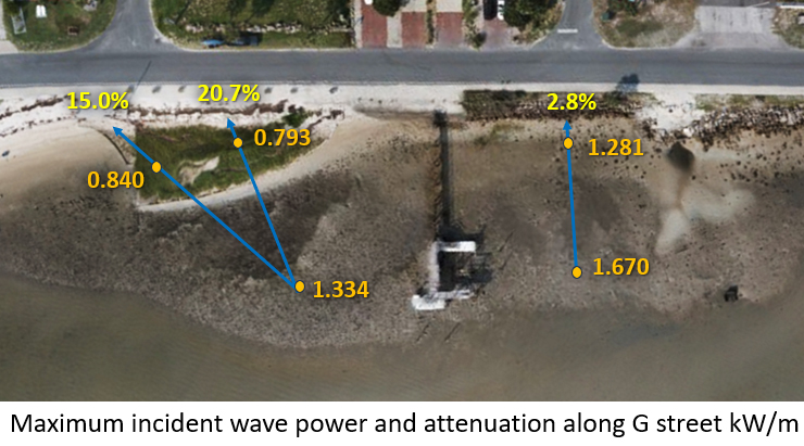
“We were able to deploy 23 wave gauges around Cedar Key, including on our living shorelines sites,” Clark said, crediting Mississippi State University Extension for the release of plans for a do-it-yourself, low-cost wave gauge in a 2020 publication. “From the moment they were deployed, each pair of wave gauges – one offshore and one nearshore – captured data 10 times per second, which was then used to determine water depth, wave height and wave energy during the storm.”
Clark said the outcomes along the living shorelines were decisive.
“All shorelines were exposed to maximum wave heights around 3.5 feet, with 8.9-foot storm surge and water depths of 5 to 10 feet,” Clark said. “The gauges showed reductions in wave energy and wave height across the sites, which tells us the living shorelines did their job in reducing the impact to the onshore infrastructure behind them.”
The impressive numbers include a 6 to 18% reduction in wave height and an 11 to 21% reduction in wave energy.
“The reduction in wave energy is an important measurement in this major storm,” Barry said. “If you think about what causes destruction in hurricanes, it’s not just the floodwaters, it’s the force behind those waves, crashing into the buildings. These living shorelines not only held the sands in place, they likely created some crucial wave breaks that minimized the damage that could have been seen.”
Adjacent shorelines highlight the successes of the living shoreline sites.
Clark points to neighboring beaches for comparison: All but one dock was severely damaged, sand was lost in the unvegetated part of G Street Beach, and hardened shorelines showed sediment erosion and potential undermining.
“All low marsh vegetation seemed to be unaffected, and the one part of Airport Road’s high marsh and dune area that had turned brown immediately after the storm was greening up several weeks later,” Clark said.
Boosted by the projects’ performance in Hurricane Idalia, Clark and Barry continue to spread the word about living shorelines as a coastal strategy, not only in Cedar Key, but also for other regions at risk for hurricane impacts.
“Cedar Key’s living shorelines are living demonstration sites,” Barry said. “Now that we’ve really seen the resilience of an established site in hurricane conditions, and have the data behind it, it’s just one more option that coastal communities should consider.”
Florida Sea Grant offers a Living Shorelines Training Course for Marine Contractors; to learn more, contact the living shorelines program assistant, Mandy Baily.
 5
5
