
All photos: Molly O’Connor
More and more visitors to the Gulf coast are seeking nature encounters when on vacation. Of course there are still the amusement park fans but there is an increasing number interested in visiting “The Real Florida” that our state park system promotes. Actually, I have found that many lifelong residents of the Florida panhandle have not visited many of the scenic natural areas of our state.
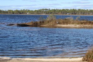
Looking from the kayak launch at Johnson’s Beach you can see across the ICW to Big Lagoon State Park. This body of water has seagrass and salt marshes along 12 miles of natural shoreline ending at an old fortification that can only be accessed by boat. There is plenty of snorkeling, birding, and fishing to do along the way.
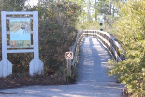
At the kayak launch at Johnson’s Beach is a short trail through the dunes of Perdido Key. You will be able to view a variety of plants and birds, or maybe, as I did, find a large coachwhip basking on a dune.
There is no doubt that to conserve something you need to love it… and to love it you need to experience it. We think if you visit some of our natural areas you will fall in love with the area and hopefully we can conserve much of it. Nature-based tourism is a way to support the local economy but we need natural areas for this to happen… fishing is not much fun without fish.
So we are going to begin a series of posts highlighting some of the nature-based tourism locations that visitors and locals can enjoy throughout the panhandle – from dunes of the coast to the forest of “north-end”. To begin the series, we will follow the Intracoastal Waterway from the Alabama state line to the Aucilla River (basically the Florida Panhandle). We begin at the western tip… Perdido Key. But first let’s talk about the Intracoastal Waterway itself.
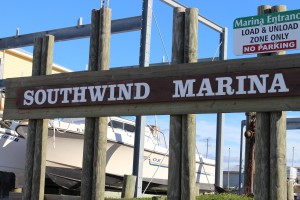
Southwind Marina is found on the northside of the ICW across from Perdido Key. For the visitor who is interested in fishing or diving the vessels can reach the Gulf in just a few minutes. Some dive charters will take you to spear lionfish.
INTRACOASTAL WATERWAY
The concept of the Intracoastal Waterway (ICW) dates back to the 19th century but construction on the northern Gulf section began in 1925. The ICW begins in Brownsville TX along the U.S. coastline to Carrabelle, FL. From here you follow a series of markers across the open Gulf to Anclote Key (near Tampa) where again the inland ICW heads to Ft. Myers. There is a canal that cuts across to Lake Okeechobee, and the east coast of Florida, but many boaters take the Florida Keys route. If crossing the state through the lake you will arrive at Jupiter Inlet on the east coast the ICW which travels north from here to Virginia – a total of about 3000 miles. The waterway was developed to make commercial shipping safer. Plans to cut a canal across north Florida from the Crystal River to the St. Augustine area never happened. The ICW consists of manmade canals, protected lagoons and sounds, and open sections of local bays.
In the Florida panhandle the ICW begins at the state line in Perdido Bay. It follows a narrow section of water north of what the locals call “Old River” between Ono Island AL and Innerarity Point FL. It eventually enters Big Lagoon in Escambia County before crossing the lower portion of Pensacola Bay. It is this portion of the ICW we will focus on in this article.
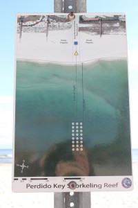
Escambia County Division of Marine Resources has provided three inshore snorkel reefs for the visitor who would like to experience a reef diving but is not a certified diver. The reefs can be found by aligning the blue square and yellow triangle on the beach. This one is on Perdido Key near Johnson’s Beach.
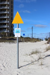
The yellow triangle used to locate the reef while you are swimming. These nearshore reefs have a variety of small reef fish and occasionally, in the warmer months, a sea turtle may visit.
PERDIDO KEY
Perdido Key is a 15-mile-long barrier island stretching from the mouth of Perdido Bay to “Ft. McRae” near NAS Pensacola in the Gulf Islands National Seashore. The we
stern end is actually in Alabama. The state line is near Ono Island and the famous Flora-Bama Bar. North of the Key is “Old River”, then Ono Island AL, then the ICW itself, and eventually Innerarity Point FL. For the nature tourist you have miles of white sandy beaches to the south which are great for shell collecting, birding, and fishing. In the summer the beach comber can find ghost crabs, flowers, and maybe a nesting sea turtle. The “river” side of the island has numerous small islets and seagrass beds that offer good birding, snorkeling, and fishing. Be aware though to stay out of the ICW here. It is very narrow and the passing barges are very large. Dive flags are required of snorkelers in Florida. There is a public kayak launch on the north side along “Old River”. Perdido Key is home to the endangered Perdido Key Beach Mouse. Many locals have lived on the island all of their lives and have not seen one… maybe you will be lucky!
As Perdido Key Drive heads north off of the Key you will find a small side road leading to Johnson’s Beach and a section of the Gulf Islands National Seashore. Just as you turn onto Johnson’s Beach Road you will find Sandy Key Road to the south. There is a public access point here and a public nearshore snorkel reef provided by Escambia County. These Gulf side reefs attract a variety of small reef fish, including many tropicals, as well as larger species such as sheepshead and snapper. Be sure to have your dive flag with you.
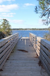
This public kayak ramp is found on the north side of Perdido Key. From here the paddler can visit several small islets and snorkel grassbeds. There’s good fishing too. The ICW is narrow here though so you need to be aware of large boat traffic.
The last 12 miles of Perdido Key is part of the Gulf Islands National Seashore. The road only goes about 2 miles of that but you are allowed to hike the rest. The southern shore is more beautiful white beaches and the north is bordered by Big Lagoon. Big Lagoon is pretty shallow and outside the ICW host a lot of seagrass. Here you can snorkel for hours and see fish, crabs, and maybe a scallop or two (they are illegal to harvest here though). Many species of birds can be found here including osprey. There is a short natural trail at the kayak launch on the lagoon side of the park where you can see a variety of dune plants, animal tracks (such as deer), and other wildlife such as coachwhip snakes and the elusive diamondback terrapin. You can paddle from the kayak launch 12 miles to the east point and “Ft. McRae”. Seagrasses, salt marshes, dunes, freshwater ponds, and assorted wildlife can be found here. Back Country Camping is allowed in this portion of the Seashore but you must register at the Ranger station.
As you leave Perdido Key you find Big Lagoon State Park on your left. Located on north shore of Big Lagoon you will find the ICW. This park provides camping, hiking, snorkeling, birding, and kayak rentals. The park has hiking trails and freshwater ponds that harbor a variety of wildlife including species of freshwater turtles. Just down Gulf Beach Highway you will find Southwind Marina, which is home to many charter boats. Also located on Big Lagoon these charters have quick access to offshore reefs in the Gulf of Mexico for those interested in diving and fishing, including trips to hunt the invasive lionfish.
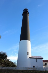
The 150′ Pensacola Lighthouse was first lit in 1859. The distinctive colors made it easy for mariners to identify from offshore and the light signal (time between flashes) is 21 seconds. This is a must see for those visiting the Perdido Key area.
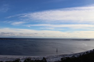
From the Pensacola Lighthouse you get a great view of the open Gulf and the eastern end of Perdido Key. Here the pass separates Perdido Key (on the right) and Santa Rosa Island.
Before you leave the Perdido Key area and head for Pensacola Beach the nature tourist should make a stop at NAS Pensacola. The 150 foot Pensacola Lighthouse is open to the public and the views of the ICW as well as the two barrier islands (Perdido Key and Santa Rosa Island) are wonderful. There is a nature trail aboard NAS called Trout Point which leads you from the main road to the ICW.
To learn more about nature trips in the Perdido Key area contact Sea Grant Agent Rick O’Connor at (850) 475-5230 or roc1@ufl.edu and to find local nature tours visit NaturallyEscaRosa.com
Next stop… Santa Rosa Island.
Posted: January 25, 2016
Category: Natural Resources, Recreation, Water
Tags: Intracoastal, Nature, Panhandle Outdoors, Perdido, Tourism, Waterway

