The ocean IS in motion. We know this just from our experience swimming in it. The waves push us back to the beach only to suck us back towards the ocean. We can toss a ball out there and watch it come in and roll out, all the while it’s moving down the beach. You put on a mask and go under. You can see seaweed, and other particles, swirling to and fro. Yes, the ocean is in motion. But what energy source is causing this? Is it a constant source, or does it change over time? Can we predict these changes in motion? And can we use them for our own good? Let’s look at these questions further.
What is the energy source causing waves, currents, and tides?
The quick answer is the sun, but it is more complicated than that.
Let’s begin with currents.
You’ll remember from our lessons on the Nature of Science that the early mariners had observed, and charted, the major ocean currents. They knew where these currents were located, which direction they traveled, and at what speeds. The Gulf Stream for example was easily detected by (a) the color of the water, (b) the speed and direction the sailing vessel began moving, and (c) the water temperature change. If the captain wanted the use of the Stream, he would enter and remain in. If he did not, they would change course to avoid. Knowing this for all of the currents they could select the ones to help them and avoid the ones that were going to be problems. What this tells us as scientists is that there is an energy source moving the water, it is constant and dependable. So, what’s driving them?
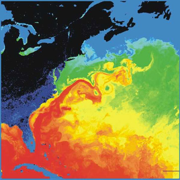
Image: Wikipedia.
At the equator there is more direct sunlight hitting the surface for a longer period of time. This warms the ocean, expands the molecules, and causes the water to rise. The colder parts of the sea, near the poles, are opposite. The colder water becomes more dense and sinks. As the cold polar water sinks towards the seafloor, warm rising equatorial waters move across the surface to fill the void of the sinking cold water. Much like the water at surface of your bathtub moves to fill the void of the water exiting the tub through the drain. So, theoretical – logically, the water at the equator would MOVE north (or south) towards the poles – but it does not move in a straight line towards the poles. It heads west then north. What’s up?
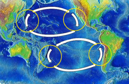
Image: NOAA
It’s called the Coriolis Effect. Imagine you have circular pizza pan. You place your marker the edge of the pizza pan and draw a line from there to the center. No problem… You can see a straight line in that direction. Now place your marker on the edge, SPIN the pizza pan and draw a line to the center. You will see that even though you made an attempt to draw a straight line, it curved. This is the Coriolis Effect. Objects that appear to be moving in a straight line are in fact curving because the earth is rotating beneath it. Airplanes have this same effect when flying from Pensacola to Denver. They set a course for a straight line but moving over a rotating sphere, it’s not exactly straight. Interestingly, you will only notice the effect if traveling over a long distance – say from Pensacola to Denver, or the equator to the north pole. This does not happen to water in Pensacola Bay or Bayou Texar – more on those in a moment.
If you can imagine looking down on the pizza pan, that the center is the North Pole and the edge the equator, the earth would be rotating counterclockwise. This would make a moving object (or water) bend to the right. If you use the same scenario but were looking at the South Pole, the movement would be to the left. This is what causes the opposite hemisphere currents to rotate in opposite directions. If you could follow a plastic ball across the Atlantic Ocean beginning at the equator, it would try to flow north towards cold water, but actually head west towards the United States. All the while sliding towards the right (Coriolis) heading north and east as it slides west. Near the poles the warm ocean current has slid across towards Ireland and becomes colder (less direct sun to fuel the energy) and the cold-water sinks, some heading back south along the coast of Europe and Africa. Once it reaches the equator the water is once again warmed, and the cycle starts again. These large ocean circulations are called gyres and as already mentioned, rotate clockwise in the northern hemisphere and counterclockwise in the southern. A phenomenon has been observed and mapped by the ancient sailors and explained by more recent science. As with any vortex like this, in the middle of the circulation is “the eye of the storm”. An area of calm water that the ancient sailors called “the doldrums” and, with no engines to get you out in their day, was to be avoided at all costs.
But what about current movement in a small body of water like Pensacola Bay or Bayou Texar? Interesting enough, many have investigated this and have some interesting observations and explanations. I know Gulf Power, and others, have set out drifting devices to measure the speed and direction of the surface currents of Pensacola Bay. Washington High School’s Marine Science Academy did something similar in Bayou Texar. I also know that Dauphin Island Sea Lab has set drifting devices out in Mobile Bay and the northern Gulf of Mexico.

Photo: NOAA
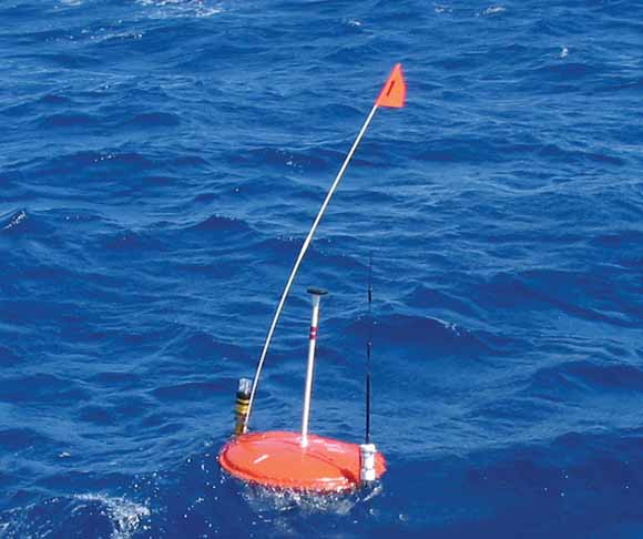
Photo: USGS
These drifting devices are concave disk with a “tail” hanging off. On this tail you can place brass rings to make the device weigh what you would like. Adjusting the weight can force the device to sink, but maybe not all the way to the bottom. Stamping your contact information on such a device, and offering some reward, will get the public to call, providing information on when and where they were found. This information can be placed in a computer model and give information on the direction the water was flowing and at what speed.
At Washington High School they used current meters designed to measure current speed I creeks and rivers. An orange flag was placed on the instrument to give indication of current direction. The instrument could be lowered every foot until you reached the bottom. Like any good experiment, these were repeated at systematic (or random) sites, and replicates repeated as often as time and money allowed. The data then analyzed and published with a confidence level the researcher felt, or mathematically determined.
The results of the Washington High School project in Texar suggested the surface waters moved in a variety of directions, but usually the same direction at all stations on the same day. The bottom water was moving independently from the surface water and was either heading into the bayou, or out, and which ever it was for that day, it was the same at all stations.
The logical explanations given?
The surface water is less dense due to lower salinity and the direction it was moving was generally from the head of the bayou (the creek) towards the mouth (the bay). This was believed to be due to freshwater from the creek heading to the bay. The variation on different days aligned well with the wind direction that day. So, the wind direction seemed to override the general freshwater flow towards the bay on windy days. The bottom water is saltier and denser. It was influenced by the tide. High tide, water was entering the bayou and moving north – low tide the opposite. Studies done on the larger Pensacola Bay system seem to follow this same pattern. Of course, with science, you could always go into the lab where you can control these variables and test this hypothesis. But there was little evidence of Coriolis here.
Here is another current phenomenon witnessed here. You set up your chair and towel for a day at the beach. You jump into the surf with your surfboard, or float, and enjoy the water. The next thing you know you have drifted down the beach – away from your chair. A current has obviously moved you but what energy source caused this?
In this case it’s waves – another form of ocean movement. So, let’s first talk about waves.

Waves are cool because (a) you can ACTUALLY see energy in motion, (b) they can be massive and awe inspiring to watch crash on the shore, and (c) you can ride them!
What do we mean by “you can see the energy in motion”?
This… As you watch a wave come from offshore towards the beach, the water is not moving with it. I mean there is some circular water movement, but not at the speed and direction of the wave – that is separate. Take the classic “wave” seen at a larger sporting event. The crowd gets going. Everyone begins to stomp their feet. One group stands and waves their hands in the air and then sits back down. The group to their right stands as the first group begins sitting. So forth and so forth. The “wave” picks up speed as it moves around the stadium. As it gets closer to your section again, the feet stomping begins and then it’s your turn – STAND-WAVE-WOO! -SIT. And so it goes until everyone is tired or bored… “The Wave”.
But here is the deal. You can SEE the wave moving around the stadium. You can actually see it. But the only movement by you is standing up and sitting down. You do not “run” with wave, but appears the wave is running THROUGH you all. This is how ocean waves work as well. Energy is pushed into the water and moves THROUGH it. As it moves through, the water “stands and sits”. Actually, if you were to place a plastic ball in the water as a wave comes by you old see it rise, move forward, go down, and back close to its original position – sort of circular (an activity given below). BUT, like you in the stadium, you did not move seats, you are in the same place, energy moved through you and YOU COULD SEE IT.
So, what happens to that energy when it meets land?
1) it can be dissipated into the sand, tossing sand everywhere and sculpting the beach.
2) it can reflect, returning into same direction from which it came.
3) refract, this is bending the wave (as we learned in lesson 2 with light). It will move in a different direction at a different speed.
This can happen when the wave makes contact the any solid surface. As mentioned above, the wave is traveling in a circular pattern. The top of the circular causes the water to rise – the wave crest – and the bottom is the wave trough. The instance between the crest and trough is known as the wave height and half of the wave height is the wave amplitude. In the open ocean, the trough is free to cycle back to the top – but close to shore it will make contact with the seafloor (either the beach or a coral reef or sunken vessel). This causes the trough to slow, but the crest is still moving at the same speed. This will cause the crest to move faster than the trough and “spill over” forming the wave break we are familiar with seeing.
As waves breaking on the beach reflect back out to sea, they will come into contact with the next incoming wave. This is a collision of two forces, and something has to give. The net force… Is a current heading down the beach known as the longshore current, or longshore drift, or littoral drift. The current that moved you from flotation of your chair. This current will continue down the beach until some submerged object blocks a wave from reaching the beach – which halts the collision with the outgoing reflected wave – and there is a strong current heading out to sea – the rip current. These rip currents are usually pretty strong due to build up energy from reflecting downtown beach. But they do run out of energy and calm just offshore. Most who drown in rip currents do so because they are trying to swim back to shore against this strong rush of water heading out. You are advised to do on of two things if you are caught in one. (1) swim parallel to the shore, not towards it – rip currents are usually not very wide, and you will be out of it so can swim back easily. (2) relax and let it take you out. They usually do not go out far, now you can swim parallel for a few yards and make it back to shore easier.
Now we did not talk about the energy source that causes waves. This, again, would ultimately be the sun. As the suns direct rays hit the earth, they warm the air it comes in contact with. This warm air rises. As the air rises, surrounding air along the surface moves across to fill the void of the rising air – sound familiar?
This air moving across the surface to fill the void is what we call wind. Rising hot air will form a low-pressure system. This is because the air moving upward decreases the air pressure at the location where it is happening. Surrounding air rushes in to fill and warms itself – rising. More air warms, more air rises, more air fills its space. In the upper atmosphere the air is cooling. This cold air becomes denser and falls back to earth in another location. Extremely hot spots can produce strong low-pressure systems (air rising very fast) and wind moving across the surface towards the low pressure will be moving very fast, and these are tropical storms. When those surface winds reach 74 mph – you have a hurricane.
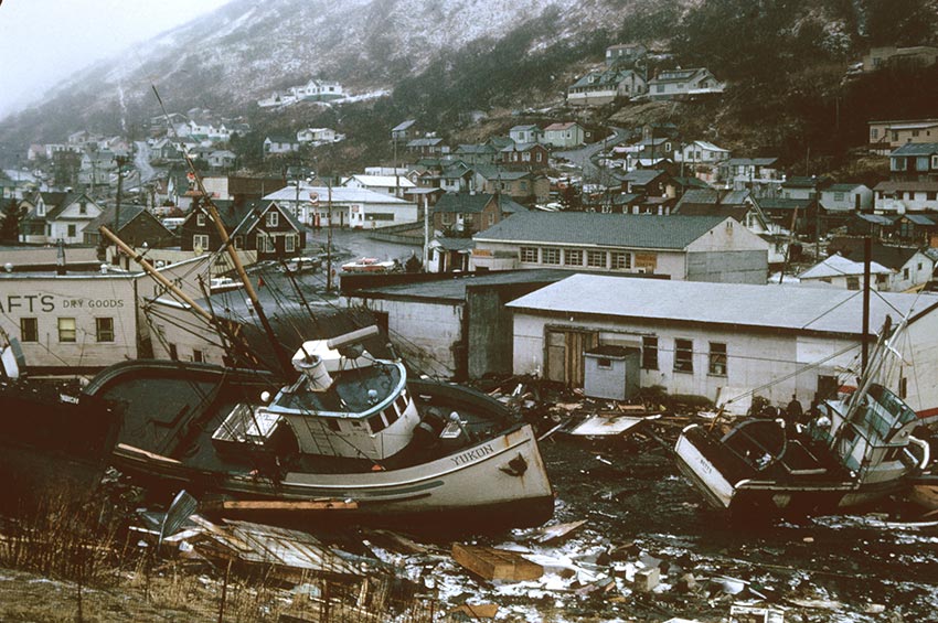
Photo: NOAA
People are usually fascinated by waves, particularly large ones. Hundreds gather along the north shore of Oahu to watch surfers ride some of the largest waves on the planet. Then there is the king of kings… Tidal waves… Tsunamis.
The Japanese word tsunami is preferred because tidal waves have nothing to do with the tides. And the energy source driving them is not the energy source forming most waves, which is wind. In this case they are shock waves, pressure waves, similar to sound. The energy causing these shock waves… earthquakes.
Earthquakes are formed along fault lines, where the earths crust is pushing against each other, splitting from each other, or sliding by each other. A sudden quick shift, if happening beneath (or near) the ocean can create a shock wave that would generate a wave. This would be like dropping a rock into a pond. As the rock hits the water you see ripples, shock waves, move out in 360°. They are usually uniform and move pretty fast towards the shore. Now imagine this on a larger scale. Imagine the pond is the ocean, the point of where the rocks hits is where the earthquake occurs, and the ripples would be the tsunami. At sea, you would probably not even notice them. The wave heights are not that large, but the wave lengths (the distance from one crest to the next) would be VERY large. Just off the beach in the Gulf of Mexico a typical wavelength could be 5-10 feet, maybe 20-30 feet. The longer the wavelength, the larger the wave, and the larger the break when it happens. The wavelength of a tsunami can be 100 miles! And, as with the rock in the pond, be moving VERY fast – maybe 100 mph. As these large waves get close to land, they will begin to draw water out, away from the beach – only to return with force… a destructive force.
As already mentioned, these waves are not formed by strong winds or storms. So, the experience would be something like this. You are at the beach for a sunny day of recreation. You set you chairs and towels down. The sky is blue. The gulls are calling. Kids are playing at the shore and older kids are playing on boogie boards just off the beach. The waves hit the beach and roll back out. Again, and again. Then… all of a sudden… the water leaves the beach for maybe a hundred yards or more. The wet seafloor is exposed, and you can see it. Then a large wall of water comes rushing back in. A big wall moving VERY fast. It completely engulfs those on the beach, covers the houses, destroys buildings and uproots trees, rushes down streets, like someone just turned on a huge hose. Like other waves, tsunamis come in sets – usually five – so this will repeat itself a couple more times. Then all is silent. But there is destruction everywhere. The scary thing about these is that you have no warning this is coming. You had no way to prepare. Tsunamis have killed a lot of people. Most occur in the Pacific due to the large amount of earthquake activity associated with the “ring of fire”. Today, there buoys scattered across the Pacific that can measure wave height, wavelength, and wave period (the time between two crest). This information can detect a tsunami while it is coming in from sea. They move fast so there is not much time. Coastal beaches will have a loud siren that goes off if one is detected nearby. If you hear this siren, you should move to high ground NOW. This has saved many lives.
This is a long lesson, but to remain close to the scope and sequence of the state marine science curriculum, we must keep pushing on. Last… Tides.
Most know that the tides are caused by the moon, but we mentioned earlier in this lesson that the ultimate source of motion in the ocean was the sun – the sun plays a role here as well.
Everyone knows the tides. The water rises and falls every day. We know it, the birds know it, the horseshoe crabs know it. Many creatures base their activities around the tides. We also know that they are cyclic, and we can predict when the next one is going to be. What is happening here?
We know that the earth is solid, and that the ocean covers 70% of the surface. We know that the earth rotates on its axis every 24 hours and revolves around the sun every 360 days. We know what keeps us in this orbit is the gravitational pull of the sun. Gravity… what is gravity?
Gravity is a natural force causing the attraction of two objects with mass (or energy, it works with light also). The strength of the attraction is a function of the objects mass and the distance they are apart. This is Sir Isaac Newton’s Law of Gravity (GF = G x (m1m2)/r2 ).
GF is the gravitational force
G is the gravitational constant (6.674 x10⁻¹¹ m3/Kg/sec2)
M1 is the mass of object #1
M2 is the mass of object #2
R is the distance between the two objects
The sun is much more massive than the earth and, at a distance of 93,000,000 miles, is strong enough to keep the planet in orbit around it. Question is… is it strong enough to pull the planet INTO it?
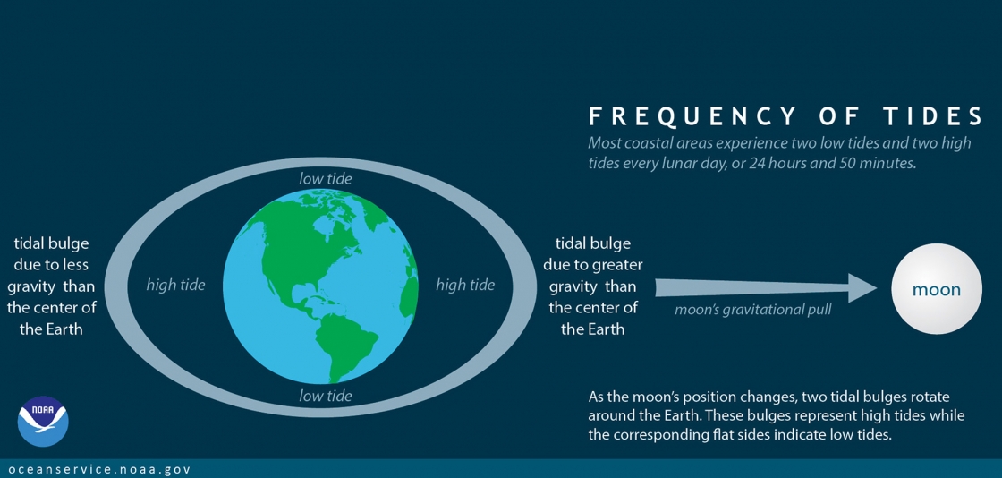
Image: NOAA
The moon-earth system is similar. The earth is more massive than the moon but at this distance (239,000 miles) we are able to keep the moon in orbit around us. We know it takes about 28 days for the moon to make a complete orbit around the earth. This is what we call a month. We also know that the moon is revolving on its axis but at a speed that we only ever see one side of it.
Not mentioned here is the fact that the smaller object (the moon) also has a gravitational pull on the earth. It is not going to move the earth, the earth is not going to orbit the moon or anything, but there is a pull and this pull CAN pull the liquid ocean on the surface. So, as the moon goes around the earth there is a bulge of water that follows it. A sort of “hill, or bump” in the ocean that moves with the location of the moon – the high tide.
The earth rotates every 24 hours. So, we, in Pensacola, will pass the moon once a day (we can see it – sometimes, more on that in a minute). So, we should see a high tide once a day – and we do. When the moon is on the opposite side of the planet, we have a low tide. This is caused by the amount of water moving towards the high tide point leaving low water on the that side of the planet. Make since?
But…
MOST of the planet, and most of Florida, has TWO high tides each day. What is that all about?
The sun. yes, the sun – always the sun.
As the moon pulls on the water forming a bulge, so does the sun. So, there are actually TWO bulges each day – two high tides each day. Why then does Pensacola only see one a day? More on that in a minute.
With the sun on one side of the planet and the moon the other, there is should be two bulges (high tides) 12 hours apart. And there should be two low tides formed as well, 12 hours apart. So, we should see a tide every 6 hours. High tide… 6 hours… low tide… six hours… high tide. And we do, sort of, the timing is a little off depending on your location.
The thing is the moon is orbiting us as we turn on our axis. So, it is in a different position each night. It takes 28 days (a month) for the moon to complete its rotation of earth. And during that time, its alignment with the sun is not always directly on the other side of the planet. When they are aligned across from each other we see a Full Moon. The sun is shining directly on the surface of the moon and we can see it all. But each night the position of the moon moves slight towards the sun’s position. The angle between them (with the earth in the middle) decreases and we see this in the “phases of the moon”. We go from Full Moon to Half Moon (when the moon-sun angle is 90°). Then it becomes a quarter moon and eventually we do not see it at night.
This is because the moon rotation now has it on the same side of the earth as the sun. We do not see it at night BUT we do see it during the day. At one point the sun and the moon are once again aligned BUT on the same side of the planet – the New Moon.
This does not change the time of the tide, but it does change its strength – how high the high tide will be. During the Full and New Moons, when the sun and moon are aligned, we have the highest high tides we will see for the month – the Spring Tides. During the Half Moon the moon is trying to pull the ocean in one direction while the sun is pulling in another – the water is not sure where to go and basically moves very little those days. So, this would be the lowest high tide of the month – what we call Neap Tides.
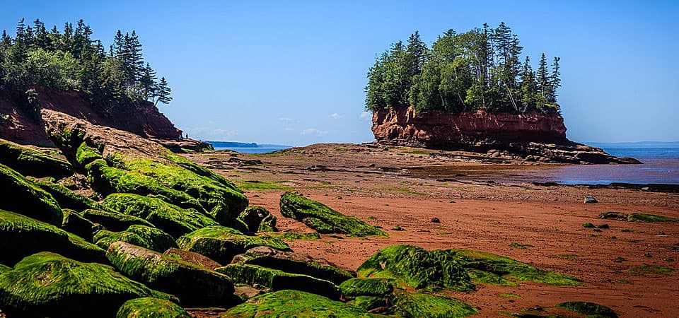
Photo: NOAA
What we mean by the lowest is the Tidal Range. The tidal range is the distance between the high and low tide. Around the planet the average tidal range is about 3 feet – 3 foot distance between where the high tide mark is and the low tide mark. During the spring tides this range could double to a 6 foot range, and during a neap tide it may only be 1 foot difference (you would hardly notice). In Pensacola, we have weak tides – a normal tidal range for us is 1 foot, we might have 3 foot spring tides, and 0.5 foot neap tides. Some locations, such as the Bay of Fundy between Maine and Canada can have 30 foot tides! Check this out on the internet. You can see the Bay of Fundy with several tree covered islands. As the tide goes out, the water exits the bay and these islands become mounds in the middle of a sandy/muddy field! Even better… during the spring high tides in Fundy there is a wave formed with the incoming tide called a Tidal Bore, they people try to ride on their kayaks. It can take you for miles up the bay… pretty cool.
Now, about Pensacola’s one high tide a day – where is the other?
A question I too have always wondered. I did go to the library and found a book of Pensacola Tides. It was 126 pages of calculus problems, I put it back on the shelf – I tell everyone “it’s a miracle” 😊
I CAN tell you this. In locations around the planet where this happens, those locations are a far distance from the open ocean. Pensacola, and much of the northern Gulf, is a LONG way from the open Atlantic. At the FAR end of the Mediterranean Sea, only one high tide within 24 hours is occurring as well. It has to do with distance traveled and time allowed. We DO get both tides, just not in a 24 hour period, we are too far away for that to happen. Single high tides like these are known as Diurnal tides. However, if you look at a tide chart of Pensacola Bay, once in a while you will see that we DO get two highs in one day (or two lows) – it does happen once in a while.
We have 3 types of tides found on the planet.
Diurnal tides – where there is a single high and low tide within 24 hours.
Semidiurnal tides – two highs and two lows within 24 hours and the tidal range is the same.
Mixed tides – two highs and two lows BUT the tidal range is not the same, one will be higher than the other.
Whew….
That was a lot for one lesson.
Here are some activities to help understand more.
ACITIVTIES
1. Ball at the beach.
This is a simple one, albeit might be cold out there this time of year. Simply toss a bright colored ball into a large body of water (the Gulf, the Sound, the Bay, a Bayou) and track which direction it is heading. Once you know the direction, mark to two points and time how long it takes for the ball to go between them. Knowing the distance and time, you should be able to calculate the speed. Feet/minute, or Feet/second, can be converted into miles/hour (1 mile = 5280 feet).
Variables that could be influencing the speed and direction are the tide, the wind, and maybe freshwater flow. Make notes of these on the day/time you do this.
Of course, to make this more scientific – you would want to repeat the experiment multiple times to see if you get the same results each time. Remember… you have to go in and get the ball back 😊
2. Wave measurements
This will take a couple of people and some measuring items. If you have a LONG measuring tape, that will be good. A yard stick (or meter stick) is needed as well.
Visit a local body of water – your choice, but you are going to have to get in.
The point of the beach where the waves are meeting will be “ground zero”. Go five feet out into the water. Record the depth of the water using your meter stick. Then, carefully, reading the number where the wave crest is passing the meter stick, and where the wave trough is passing the meter stick. Read AT LEAST three of these before you record a number. For example:
Let’s say at 5 feet from shore the water is 20 cm deep (8 inches). As the waves move by let’s say I see the crest pass 24, 24, and 26 cm. I’ll record 25 cm as the crest. And for the trough I see 18, 18, 19 cm. I’ll record the trough as 18 cm. Thus, the wave height (crest-trough) would be 7 cm high. You have a 7cm wave. Huge eh?
Now move to 10 feet from shore and repeat. Continue this until you can no longer go any deeper. You may have to change from 5 feet distance to 3 feet – you can adjust this however you wish.
How does the wave height change with water depth?
At the furthest point you measured hold the meter stick until a wave passes it. Time how long it takes the wave to reach the beach. Repeat this at least two more times. Determine the average time. Knowing your distance from the beach (let’s 10 feet) and the time it took the wave to reach the beach (let’s say 4 seconds) we can determine the speed of the wave (distance/time) – (10 feet / 4 seconds) – (2.5 feet/sec) – (.0004734miles/sec; 5280 feet = 1 mile) – (.0284miles/min; 60 seconds in a minute) – (1.7mph; 60 minutes in an hour).
You can do this same experiment in an aquarium or bathtub only the depth will not change, but you do not have to go anywhere. 😊
3. Rock in a pond
I do not know if you live near a pond, or lake, or bayou, but this should work for either. Toss a relatively large rock, or shell, into the water. Time how long it takes for the ripple waves to reach the shore. If you know the distance (will be hard unless you have some method of measuring it) you can calculate the wave speed. IF you do activity #2, compare the speeds of these ripple waves to those being generated by the wind… how do they compare?
This to can be done in a kiddie swimming pool, a regular pool, an aquarium.
4. Fundy tides
Do an internet search for a video of the Bay of Fundy tides. It will be amazing to see. How do you think the locals who live on this bay deal with getting in their boats at dock where the tide is 30 feet below the dock at low tide? How would you deal with this?
5. Graphing local tides
Find an internet site that provides the tides for Pensacola Bay during the month of December 2020. They should give you not only the time of high tide each day, but the height of high tide each day (or they may give you the tidal range). If they do not give you the tidal range, you can calculate this by subtracting low tide from high tide. You will have the tidal range for each day of December. Now let’s graph this. Remember the dependent variable always goes on the y-axis. In this case the dependent variable is the tidal range. The tidal range is DEPENDENT on the day. So, the day (independent variable) would go on the x-axis.
Produce the graph.
Now go on the internet and find out which day the full moon, new moon, and the 2 half moons are for the month of December 2020. Highlight those days on the graph with a highlighter making a vertical line. Do you notice a pattern?
YOUTH ACTIVITIES
If you can, take your young one down the to the water on a sunny morning. Notice where the water is touching the land. Place a stick (or some sort of marker there). You can toss a bright colored ball out there and ask them to tell you which way it is going (remember… you have to go get it 😊).
Enjoy exploring the beach while you are there. What has the tide brought in?
Now, return later that afternoon.
Where is the water now? Is your maker further away from the water? Or is it IN the water?
Time for a discussion 😊
 0
0
