Water Markers
Many boaters wonder why there are so many different types of markers out there in navigational waters, and how they work. Well, it works just like road signs, and they are as important to keep us safe in the water. On the road, some signage is ruled by the Department of Transportation (DOT). While in the water is ruled by The US Coast Guard (USCG). Within the “city” limits, the signage is managed by the local government following federal and state rules. While in the water the signage is managed by the County, following State (Florida Fish and Wildlife Conservation Commission – FWC) rules. So, we basically have two groups of waterway markers. The ones managed by the USCG and the ones ruled by local government agencies.
 The USCG is responsible for installing, maintaining, and managing the channel markers and other navigational aids that help boaters go from the opening of a river or waterway into the ocean. Usually, these signs star as “Marker #1”, and numbering increases depending on the conditions of each channel. These markers are usually located over a single piling. They have a red or green square or triangular signage with consecutive numbers marking the channel.
Through County Ordinances, The Taylor County Board of County Commissioners (BOCC), has established different “Boating Restricted Areas” with the intent to provide safety navigation within inner canals. These restricted areas are permitted by FWC following a Uniform Waterway Markers guidelines (UWM). These areas respond to hazards to navigation, like shallow areas, rocks, oyster beds, sharp curbs with low visibility during navigation, swimming areas, among many others. Each area is designed specifically for its needs to address such risks.
Restricted areas
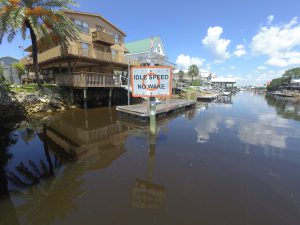
 For example, Steinhatchee river’ Boating Restricted Area is ruled by County Ordinance No. 2001-8, and FWC Permit 2006-036, and includes 17 markers along the river. The signs for the county-ruled markers are rectangular, posted on single or double piles, with a white background and an orange reflective border, and state three main rules: 1) Resume Normal Safe Operation; 2) Slow Speed Minimum Wake; and 3) Idle Speed No Wake. All Taylor County waterways are ruled by a county ordinance. This includes Steinhatchee river, Keaton Beach canals, Spring Warrior, Econfina, and Aucilla river. A set of markers, and incorporate navigational aids like buoys, bird racks, and river light systems.
Remember, a vessel that is operating at idle speed is proceeding at the minimum speed that will maintain the steerageway of the vessel while producing no wake. On the other hand, a vessel that is operating at slow speed is completely off the plane. It has settled into the water and is proceeding without a wake or with minimum wake. Please, be aware of the difference between both of them.
If you find a problem with a USCG or County/City own waterway marker (missing, non-reflective or other), please report it to the County Office or FWC using the form found here. Every year before the fishing or harvesting seasons the counties contact the USCG to check all markers in coastal areas. This time of year the number of boaters and the risk of collision or incidents increases. Also, please help protect these markers as they are paid with pax-payers money. If you see anyone vandalizing a marker take a video/photo and report it to the local authorities.
 0
0
