
November was an unusually wet month across the Panhandle with fairly wide variation. According to the National Weather Service estimates, the hot pink portions of Okaloosa, Walton, Washington, Holmes, Jackson, Liberty, Franklin, Wakulla and Leon Couties had over 10″, while the tan portions of Calhoun and Santa Rosa had less than 5″ in November. While the rainfall did improve the drought situation in the region, harvest delays have been very troublesome for area farmers. Thousands of acres of cotton in the wetter areas have yet to be harvest. Weather delays have reduced both the yield and quality of cotton, soybean, and peanuts harvested in the region.
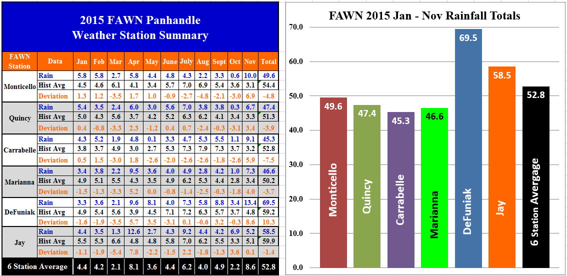 The six Florida Automated Weather Network (FAWN) station data also shows the variation of rainfall in the month of November. The De Funiak station was once again the wettest location with 13.4 inches, while only 5.2″ was recorded at the Jay station. For the first time since April, all six stations were above historic average for the month. For the year the De Funiak station has recorded over 69″, and Carrabelle remains the driest site with just over 45″ for the year. The six stations have averaged a total of almost 53″ for the year, but only the De Funiak Station has received above average rainfall, coming in 10″ above the average through 11 months.
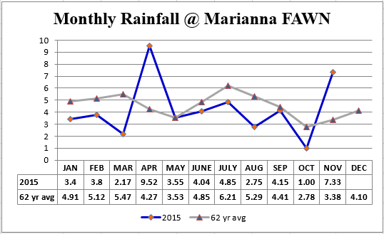 Rainfall averages and totals can be deceiving. For the year the Marianna station is only 3.7″ below average, but that was because of the excessive rain that fell in April and November. All of the other nine months were at or below average.
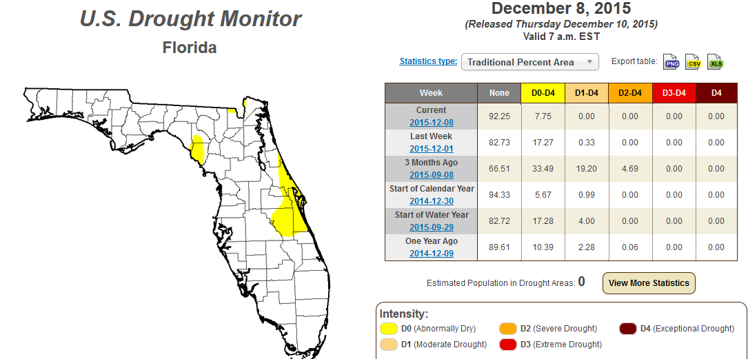 The U.S. Drought Monitor shows that the Panhandle is back in the normal range for the first time since early June. Area farmers would have much preferred a more even distribution of rainfall this year, but the water recharge from November rains is positive for farming in 2016.
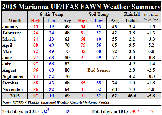 Temperatures cooled off some in November as expected. The average air temperature only dropped 4 degrees, from 68 to 64, and average soil temperatures six degrees from 74 to 68. November was certainly a month of transition with a low of 32 degrees and a high for the month of 86. Download the daily weather data with more specific records for the Marianna Station: 2015 Marianna Jan-Nov Weather Summary
December Outlook
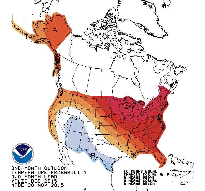
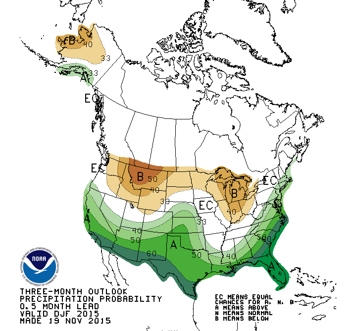
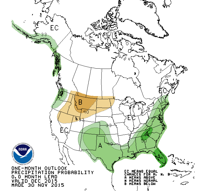 The Climate Prediction Center is expecting warmer than average temperatures and above average rainfall in the Panhandle for the month of December. The longer range forecast for December through February does not call for warmer than average temperatures, but does predict significantly higher rainfall totals based on the latest El Niño report.
 El Niño Report
The National Weather Service’s Climate Prediction center issued their latest El Niño Advisory on December 10th:
A strong El Niño continued during November, as indicated by well above-average sea surface temperatures across the central and eastern equatorial Pacific Ocean. Most models indicate that a strong El Niño will continue through the Northern Hemisphere winter 2015-16, followed by weakening and a transition to ENSO-neutral during the late spring or early summer. The forecaster consensus remains nearly unchanged from last month, with the expectation that this El Niño will rank among the three strongest episodes dating back to 1950. El Niño has already produced significant global impacts and is expected to affect temperature and precipitation patterns across the United States during the upcoming months(the 3-month seasonal outlook will be updated on Thursday,December 17th). Seasonal outlooks indicate an increased likelihood of above-median precipitation across the southern tier of the United States, and below-median precipitation over the northern tier of the United States. Above-average temperatures are favored in the West and northern half of the country with below-average favored in the southern Plains and along the Gulf Coast.
 0
0
