
**Article written August 2021, consult the National Hurricane Center for current tropical weather conditions.**
There’s another disturbance brewing in the Atlantic, and currently Tropical Storm Fred seems to be heading our way. Mid-August through September, the water in the equatorial and temperate oceans have absorbed all the summer heat and are primed for storm development. As school kicks off and we fight off another spike in COVID-19, the last thing anybody wants is another hurricane. But I thought it might be interesting to look a little deeper into how these phenomena form. What’s the deal with dust from the Sahara? And why the spinning motion with the perfect circular eye? I will give the disclaimer that I am neither oceanographer nor meteorologist, but I will give it a shot.
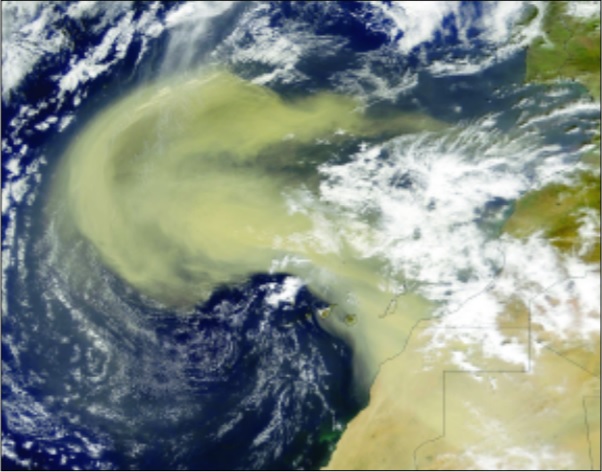
According to NASA researchers, 85% of major (Category 3+) hurricanes start on the western coast of north Africa. Far above the Sahara Desert is the Saharan Air Layer, a gigantic area almost the size of the continental United States, which forms large dust storms every 3-5 days during the summer. When the dust moves offshore, waves developing to the south pull moisture into the atmosphere. When large dust storms are present, they actually suppress the development of tropical storms, preventing tropical waves from becoming hurricanes. Essentially, the dust storms throw a dry blanket over all that hot, wet energy. However, if a wave forms off the African coast at a low point in the dust storm cycle or geographically south of the Saharan Air Layer, it can feed of the moist air south of the desert and pick up momentum.
These disturbances in the atmosphere create convective waves, which along with existing winds, push the water west. A convective wave forms when heated water travels away from its source, taking the thermal energy along. The water expands, losing density, therefore rising as water vapor and pushing cool air below it. This results in a low-pressure system underneath. This repeated sinking of dry air and rising warm air starts the tropical wave, which drifts across the 80+ degree weather in the mid-Atlantic, pulling in humid air like fuel. Wind blowing across the Atlantic from Africa speeds up the evaporation process.

As the water rises into the air, it cools and forms large cumulonimbus storm clouds. The rising warm air and winds start moving in that telltale counterclockwise circular pattern around a center and gathers larger storm clouds. In the northern hemisphere, our storms circulate counterclockwise due to the Coriolis effect, which means the equator spins faster than the poles, increasing the velocity and essentially spinning winds from the northern hemisphere to curve west towards the equator. Movement of air from high to low pressure sends them into a right-bearing circular motion, which results in a spin to the left (counterclockwise). The center eye of a hurricane receives the cooler, sinking low pressure air, which pushes clouds away. This calmer area is encircled by a high wall of powerful storm clouds, which spin wind and rain bands outward. If those winds reach a sustained 39 mph, you’ve got a tropical storm that may develop into a hurricane. Once storms enter the Gulf of Mexico, which holds heat more consistently and at higher rates than the Atlantic, hurricanes can build in intensity. According to Kevin Trenberth, a senior scientist at NOAA’s National Center for Atmospheric Research in Boulder, Colorado, “High sea surface temperatures lead to the evaporation of moisture, which provides fuel for the storm. Then it gives up the latent heat: that is what powers the storm. Together they provide for stronger storms. The evidence is abundantly clear.”
Hurricanes can be 1,000 miles wide and 10 miles high, sucking up humid air and fueling themselves into bigger, larger storms. Land and offshore winds can break up or redirect storms, making their paths unpredictable even with cutting edge satellite technology. While no projection is perfect, the United States has satellites scanning images of the world’s oceans every 5 minutes. These days, our predictions come much earlier and are more reliable than generations past, allowing us to prepare, get out of harm’s way, and save property and lives.
 0
0
