May Rainfall
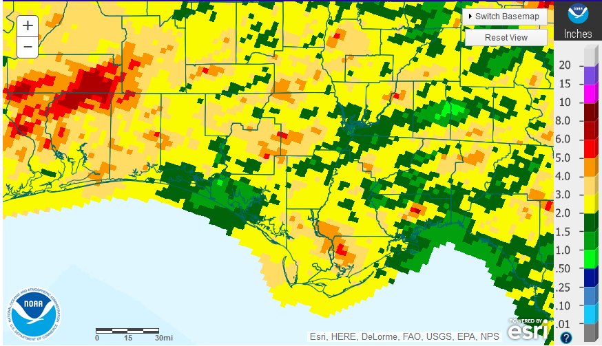
May was a more typical rainfall month for the Panhandle with El Niño disappearing. In the graphic above you can see that only small portions of northern Escambia and Santa Rosa Counties received more than 8″ for the month, while the areas in green less than 2″. Most of the region ranged from 2-5″ in May 2016.
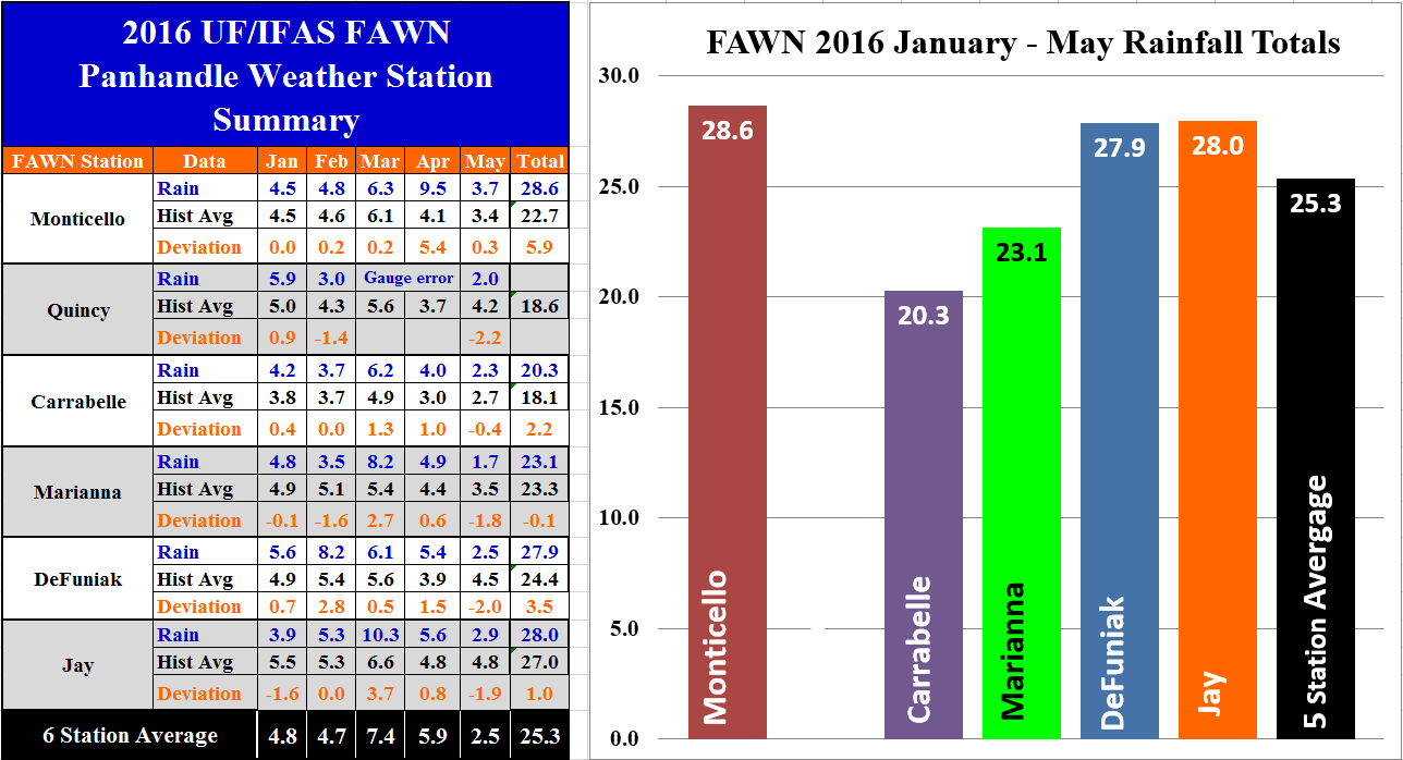 The Florida Automated Weather Network (FAWN) stations recorded rainfall in May that ranged from a low of 1.7″ at the Marianna station to a high of 3.7″ in Monticello. Only the Monticello station recorded rainfall totals above historic averages for these six locations. All six stations average 2.5″ for May 2016.
Through the first five months of 2016, the five stations averaged 25.3″ (Quincy had a gauge error in parts of March and April). Monticello had the highest rainfall total so far in 2016 with a total of 28.6″, and the lowest total of 20.3″ was recorded at the Carrabelle station. All 5 stations averaged 25.3″ from January through May. Only the Marianna site was slightly below average for the year, with the Monticello almost 6″ above the historic average for this location.
May Temperatures
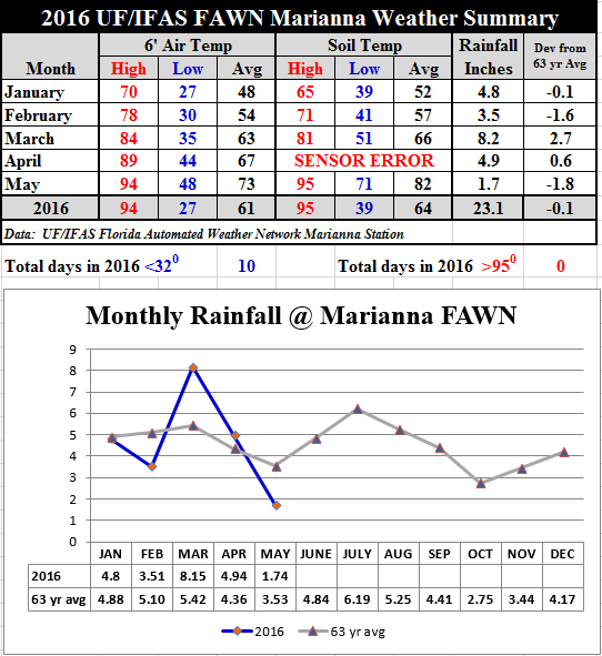
Temperatures climbed up significantly in May, with an average air temperature of 73 and an average soil temperature of 82. The data gathered at the Marianna station shows the wide variation of temperatures, however, ranging from a low of 48° to a high of 94° in May.
Tropical Storm Colin
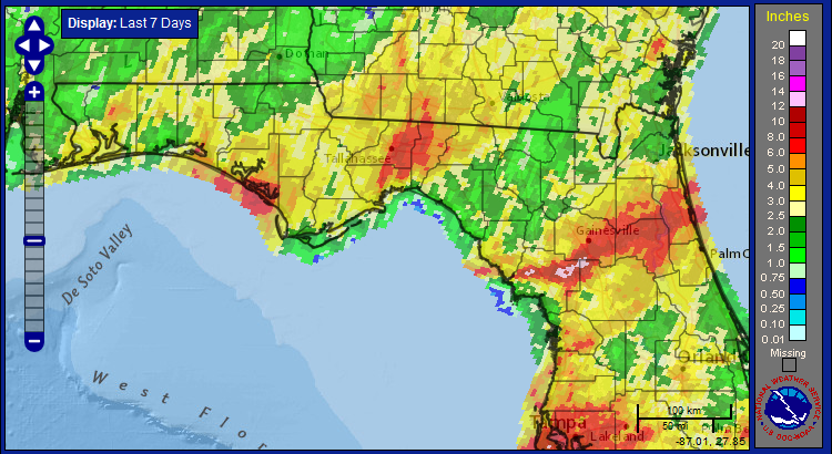
In most of the Panhandle, Tropical Storm Colin brought much needed rain for the region. While not included in the weekly drought monitor, most of the Panhandle was starting to really dry out. The areas around Tallahassee, Gainesville, Palatka, and Tampa received more than 7″ with this storm, but most of North Florida had 2-5″ over the past week.
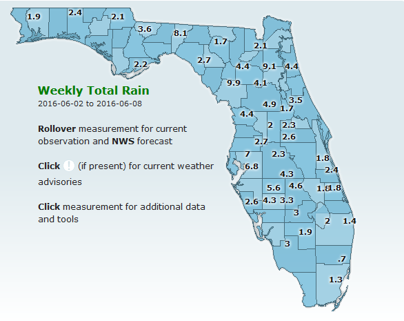
The FAWN stations show how some areas of Florida had much higher rainfall totals associated with this storm than most of the Panhandle. The Bronson FAWN station recorded 9.9″, Putnam Hall 9.1″, Monticello 8.1″, and Dover 7″ over the past seven days.
Summer Outlook
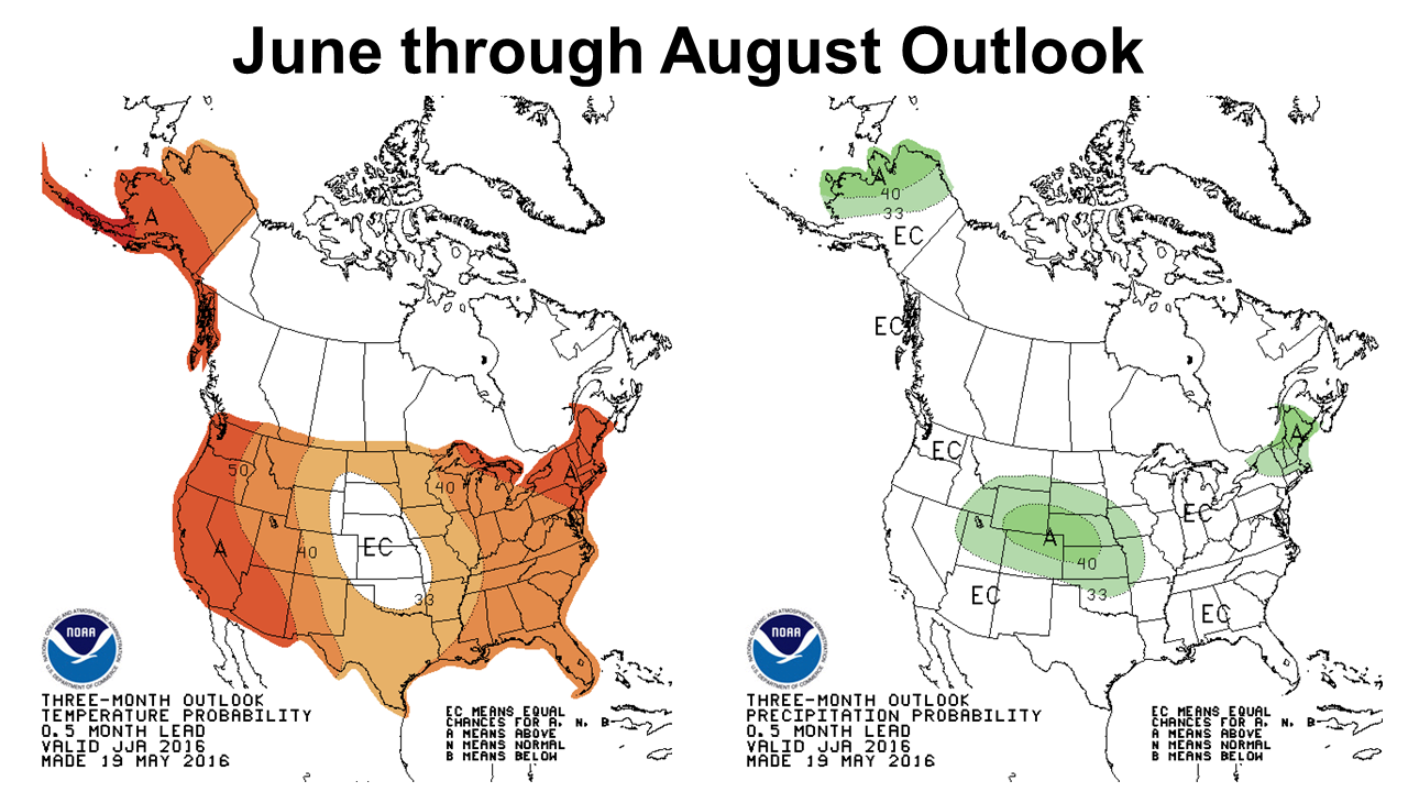
The climate prediction center is expecting temperatures to climb up over the next three months, but makes no projection for rainfall in the Southeast.
El Niño to La Niña
The 2015-16 El Niño is officially over. There is still a good chance of a weak to moderate La Niña developing this summer or fall, but as of right now the official stage is neutral. La Niña may bring good news for crop harvest this year, but may not be as favorable for winter crop and forage production.
El Niño dissipated and ENSO-neutral conditions returned in May. ENSO-neutral conditions are present and La Niña is favored to develop during the Northern Hemisphere summer 2016, with about a 75% chance of La Niña during the fall and winter 2016-17. Climate Prediction Center
 0
0
